
Spenden
Rüste dich für dein nächstes Abenteuer:
Als Amazon-Partner verdient diese Website an qualifizierten Käufen, ohne zusätzliche Kosten für Sie.
Topografische Karte Borra Caves
Klicken Sie auf die Karte, um die Höhe anzuzeigen.
Spenden
Rüste dich für dein nächstes Abenteuer:
Als Amazon-Partner verdient diese Website an qualifizierten Käufen, ohne zusätzliche Kosten für Sie.
Borra Caves
The Borra Caves (Borrā Guhalu) are located on the East Coast of India, in the Ananthagiri hills of the Araku Valley (with hill ranges' elevation varying from 800 to 1,300 m (2,600 to 4,300 ft)) of the Alluri Sitharama Raju district in Andhra Pradesh. The caves, one of the largest in the country, at an elevation of about 705 m (2,313 ft), distinctly exhibit a variety of speleothems ranging in size and irregularly shaped stalactites and stalagmites. The caves are basically karstic limestone structures extending to a depth of 80 m (260 ft), and are considered the deepest caves in India. The native name for the caves is Borrā Guhalu where Borra means abdomen in and Guhalu means caves in Telugu language.
Spenden
Rüste dich für dein nächstes Abenteuer:
Als Amazon-Partner verdient diese Website an qualifizierten Käufen, ohne zusätzliche Kosten für Sie.
Über diese Karte
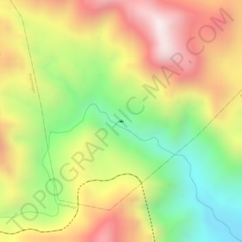
Name: Topografische Karte Borra Caves, Höhe, Relief.
Durchschnittliche Höhe: 671 m
Minimale Höhe: 282 m
Maximale Höhe: 1.024 m
Spenden
Rüste dich für dein nächstes Abenteuer:
Als Amazon-Partner verdient diese Website an qualifizierten Käufen, ohne zusätzliche Kosten für Sie.