
Topografische Karte Alones
Interaktive Karte
Klicken Sie auf die Karte, um die Höhe anzuzeigen.
Über diese Karte
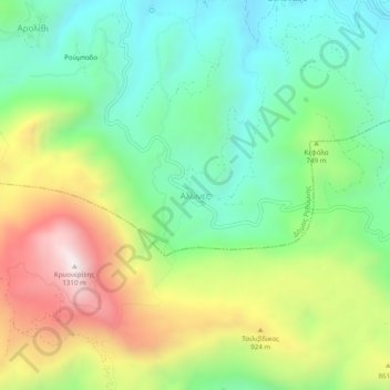
Name: Topografische Karte Alones, Höhe, Relief.
Durchschnittliche Höhe: 691 m
Minimale Höhe: 336 m
Maximale Höhe: 1.296 m
Andere topografische Karten
Klicken Sie auf eine Karte, um ihre Topografie, ihre Höhe und ihr Relief anzuzeigen.
Atsipopoulo
Greece > Region of Crete > Rethymno Regional Unit
Atsipopoulo, Municipality of Rethymnon, Rethymno Regional Unit, Region of Crete, 741 32, Greece
Durchschnittliche Höhe: 143 m
Preveli Palmbeach
Greece > Region of Crete > Rethymno Regional Unit
Preveli Palmbeach, Municipality of Agios Vasileios, Rethymno Regional Unit, Region of Crete, Greece
Durchschnittliche Höhe: 86 m
Rethymno
Greece > Region of Crete > Rethymno Regional Unit > Rethymno
Rethymno, Municipality of Rethymnon, Rethymno Regional Unit, Region of Crete, 741 31, Greece
Durchschnittliche Höhe: 204 m
Gerani
Greece > Region of Crete > Rethymno Regional Unit > Gerani
Gerani, Municipality of Rethymnon, Rethymno Regional Unit, Region of Crete, Greece
Durchschnittliche Höhe: 126 m
Plakias
Greece > Region of Crete > Rethymno Regional Unit
Plakias, Municipality of Agios Vasileios, Rethymno Regional Unit, Region of Crete, 740 60, Greece
Durchschnittliche Höhe: 123 m
Agia Galini
Greece > Region of Crete > Rethymno Regional Unit > Agia Galini
Agia Galini, Municipality of Agios Vasileios, Rethymno Regional Unit, Region of Crete, 74056, Greece
Durchschnittliche Höhe: 127 m
Vlichada
Greece > Region of Crete > Rethymno Regional Unit
Vlichada, Municipality of Milopotamos, Rethymno Regional Unit, Region of Crete, Greece
Durchschnittliche Höhe: 261 m