
Topografische Karte Iron Mountain
Interaktive Karte
Klicken Sie auf die Karte, um die Höhe anzuzeigen.
Über diese Karte
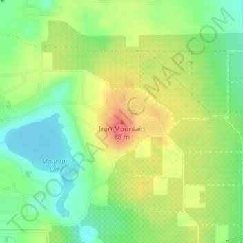
Name: Topografische Karte Iron Mountain, Höhe, Relief.
Ort: Iron Mountain, Polk County, Florida, 33853, United States (27.93664 -81.57735 27.93674 -81.57725)
Durchschnittliche Höhe: 60 m
Minimale Höhe: 29 m
Maximale Höhe: 97 m
Andere topografische Karten
Klicken Sie auf eine Karte, um ihre Topografie, ihre Höhe und ihr Relief anzuzeigen.
Bartow
United States > Florida > Polk County
Bartow, Polk County, Florida, United States
Durchschnittliche Höhe: 46 m
Davenport
United States > Florida > Polk County > Davenport
Davenport, Polk County, Florida, 33836, United States
Durchschnittliche Höhe: 40 m
Bok Tower
United States > Florida > Polk County
Bok Tower, Bok Tower Road, Polk County, Florida, 33853, United States
Durchschnittliche Höhe: 60 m
Rattlesnake Hammock
United States > Florida > Polk County
Rattlesnake Hammock, Polk County, Florida, United States
Durchschnittliche Höhe: 21 m
Kathleen
United States > Florida > Polk County > Kathleen
Kathleen, Polk County, Florida, United States
Durchschnittliche Höhe: 46 m
Lakeland
United States > Florida > Polk County
Lakeland, Polk County, Florida, United States
Durchschnittliche Höhe: 44 m
Polk City
United States > Florida > Polk County > Polk City
Polk City, Polk County, Florida, United States
Durchschnittliche Höhe: 43 m