
Topografische Karte Prachuap Khiri Khan Province
Interaktive Karte
Klicken Sie auf die Karte, um die Höhe anzuzeigen.
Über diese Karte
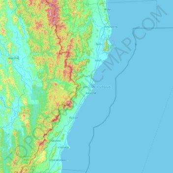
Name: Topografische Karte Prachuap Khiri Khan Province, Höhe, Relief.
Ort: Prachuap Khiri Khan Province, Thailand (10.94345 99.14342 12.63484 100.23285)
Durchschnittliche Höhe: 105 m
Minimale Höhe: -1 m
Maximale Höhe: 1.251 m
Prachuap Khiri Khan covers an area totaling 6,367 square kilometers (2,458 sq mi). The province is on the Kra Isthmus, the narrow land bridge connecting the Malay Peninsula with mainland Asia. The province has the narrowest part of Thailand, just 12.38 km (7.69 mi) from the Gulf of Thailand to the border with Myanmar in the Tenasserim Hills. Geographically, Prachuap Khiri Khan is a moderate plain with elevations varying from sea level to 1,200 m (3,900 ft). The maximum elevations are found in the northeastern and central west regions, which make up approximately 30 percent of the province.
Andere topografische Karten
Klicken Sie auf eine Karte, um ihre Topografie, ihre Höhe und ihr Relief anzuzeigen.
Khao Yai
Thailand > Prachuap Khiri Khan Province
Khao Yai, Prachuap Khiri Khan Province, Thailand
Durchschnittliche Höhe: 709 m