
Topografische Karte Pamlico County
Interaktive Karte
Klicken Sie auf die Karte, um die Höhe anzuzeigen.
Über diese Karte
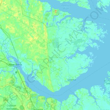
Name: Topografische Karte Pamlico County, Höhe, Relief.
Ort: Pamlico County, North Carolina, United States (34.95030 -76.98758 35.36043 -76.30414)
Durchschnittliche Höhe: 5 m
Minimale Höhe: -11 m
Maximale Höhe: 39 m
The county was formed in 1872 from parts of Beaufort and Craven counties. It was named for Pamlico Sound, which adjoins it. Vernacular usage in the area, especially in Craven County, refers to Pamlico County as being "down in the county." Prior to 1872, it was a part of Craven County and has a very low elevation. Most of the county, according to FRIS, North Carolina Flood Risk Information System, is subject to flooding in storm surges. After it was separated from Craven, the old nickname survives. Pamlico County remains rural in character and flavor, although the last decade has brought a good deal of residential development, largely the result of northern retirees and investors attracted to the many miles of waterfront property.
Andere topografische Karten
Klicken Sie auf eine Karte, um ihre Topografie, ihre Höhe und ihr Relief anzuzeigen.
Vandemere
United States > North Carolina > Pamlico County
Vandemere, Pamlico County, North Carolina, 28587, United States
Durchschnittliche Höhe: 2 m
Oriental
United States > North Carolina > Pamlico County
Oriental, Pamlico County, North Carolina, United States
Durchschnittliche Höhe: 3 m
Alliance
United States > North Carolina > Pamlico County
Alliance, Pamlico County, North Carolina, United States
Durchschnittliche Höhe: 4 m
Ball Creek
United States > North Carolina > Pamlico County > Florence
Ball Creek, Florence, Pamlico County, North Carolina, 28556, United States
Durchschnittliche Höhe: 2 m