
Spenden
Rüste dich für dein nächstes Abenteuer:
Als Amazon-Partner verdient diese Website an qualifizierten Käufen, ohne zusätzliche Kosten für Sie.
Topografische Karte Mustang Ridge
Klicken Sie auf die Karte, um die Höhe anzuzeigen.
Spenden
Rüste dich für dein nächstes Abenteuer:
Als Amazon-Partner verdient diese Website an qualifizierten Käufen, ohne zusätzliche Kosten für Sie.
Über diese Karte
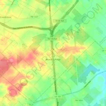
Name: Topografische Karte Mustang Ridge, Höhe, Relief.
Ort: Mustang Ridge, Travis County, Texas, United States (30.02062 -97.71265 30.10324 -97.63016)
Durchschnittliche Höhe: 187 m
Minimale Höhe: 152 m
Maximale Höhe: 229 m
Spenden
Rüste dich für dein nächstes Abenteuer:
Als Amazon-Partner verdient diese Website an qualifizierten Käufen, ohne zusätzliche Kosten für Sie.
Andere topografische Karten
Klicken Sie auf eine Karte, um ihre Topografie, ihre Höhe und ihr Relief anzuzeigen.
Spenden
Rüste dich für dein nächstes Abenteuer:
Als Amazon-Partner verdient diese Website an qualifizierten Käufen, ohne zusätzliche Kosten für Sie.
Eastwoods Neighborhood Park
United States > Texas > Travis County > Austin
Durchschnittliche Höhe: 182 m
Austin
United States > Texas > Travis County
The elevation of Austin varies from 425 feet (130 m) to approximately 1,000 feet (305 m) above sea level. Due to the fact it straddles the Balcones Fault, much of the eastern part of the city is flat, with heavy clay and loam soils, whereas the western part and western suburbs consist of rolling hills on the…
Durchschnittliche Höhe: 203 m
Spenden
Rüste dich für dein nächstes Abenteuer:
Als Amazon-Partner verdient diese Website an qualifizierten Käufen, ohne zusätzliche Kosten für Sie.
West Lake Hills
United States > Texas > Travis County > West Lake Hills > West Lake Hills
Durchschnittliche Höhe: 213 m
Spenden
Rüste dich für dein nächstes Abenteuer:
Als Amazon-Partner verdient diese Website an qualifizierten Käufen, ohne zusätzliche Kosten für Sie.
Spenden
Rüste dich für dein nächstes Abenteuer:
Als Amazon-Partner verdient diese Website an qualifizierten Käufen, ohne zusätzliche Kosten für Sie.
Longview Neighborhood Park
United States > Texas > Travis County > Austin
Durchschnittliche Höhe: 234 m
Barton Creek Greenbelt -- Gus Fruh Access
United States > Texas > Travis County > Austin
Durchschnittliche Höhe: 192 m
Mary Moore Searight zMetropolitan Park
United States > Texas > Travis County > Austin
Durchschnittliche Höhe: 201 m
Spenden
Rüste dich für dein nächstes Abenteuer:
Als Amazon-Partner verdient diese Website an qualifizierten Käufen, ohne zusätzliche Kosten für Sie.
Walnut Creek Metropolitan Park
United States > Texas > Travis County > Austin
Durchschnittliche Höhe: 214 m
Spenden
Rüste dich für dein nächstes Abenteuer:
Als Amazon-Partner verdient diese Website an qualifizierten Käufen, ohne zusätzliche Kosten für Sie.
Tarrytown Neighborhood Park
United States > Texas > Travis County > Austin
Durchschnittliche Höhe: 179 m
Spenden
Rüste dich für dein nächstes Abenteuer:
Als Amazon-Partner verdient diese Website an qualifizierten Käufen, ohne zusätzliche Kosten für Sie.
Mabel Davis District Park
United States > Texas > Travis County > Austin
Durchschnittliche Höhe: 191 m