
Topografische Karte Aizawl
Interaktive Karte
Klicken Sie auf die Karte, um die Höhe anzuzeigen.
Über diese Karte
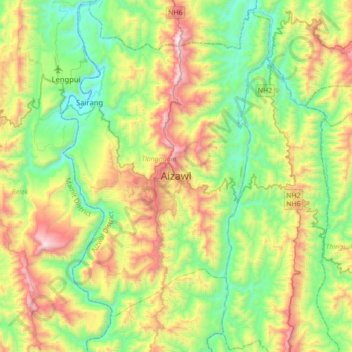
Name: Topografische Karte Aizawl, Höhe, Relief.
Ort: Aizawl, Tlangnuam, Aizwal District, Mizoram, 796190, India (23.58335 92.57828 23.90335 92.89828)
Durchschnittliche Höhe: 556 m
Minimale Höhe: 60 m
Maximale Höhe: 1.509 m
Aizawl has a mild, sub-tropical climate due to its location and elevation. Under the Köppen climate classification, Aizawl features a humid subtropical climate (Cwa) but very rainy. In the summer the temperature ranges from 20–30 °C (68–86 °F), and in the winter 11–21 °C (52–70 °F).