
Topografische Karte Britton Hill
Interaktive Karte
Klicken Sie auf die Karte, um die Höhe anzuzeigen.
Über diese Karte
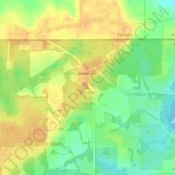
Name: Topografische Karte Britton Hill, Höhe, Relief.
Ort: Britton Hill, Walton County, Florida, 32538, United States (30.98636 -86.28157 30.98646 -86.28147)
Durchschnittliche Höhe: 93 m
Minimale Höhe: 73 m
Maximale Höhe: 109 m
Britton Hill is the highest natural point in the state of Florida, United States, with a summit elevation of 345 feet (105 m) above mean sea level. Britton Hill is the lowest state highpoint in the United States, 103 feet (31 m) lower than the next lowest highpoint, Ebright Azimuth in Delaware, and far lower than many skyscrapers in Miami and other urban areas of Florida.
Andere topografische Karten
Klicken Sie auf eine Karte, um ihre Topografie, ihre Höhe und ihr Relief anzuzeigen.
Freeport
United States > Florida > Walton County
Freeport, Walton County, Florida, 32439, United States
Durchschnittliche Höhe: 14 m
LaGrange Bayou
United States > Florida > Walton County
LaGrange Bayou, Walton County, Florida, 32439, United States
Durchschnittliche Höhe: 3 m
DeFuniak Springs
United States > Florida > Walton County
DeFuniak Springs, Walton County, Florida, 32435, United States
Durchschnittliche Höhe: 56 m
Miramar Beach
United States > Florida > Walton County
Miramar Beach, Walton County, Florida, United States
Durchschnittliche Höhe: 2 m
Villa Tasso
United States > Florida > Walton County > Villa Tasso
Villa Tasso, Walton County, Florida, United States
Durchschnittliche Höhe: 5 m
Cypress River
United States > Florida > Walton County
Cypress River, Walton County, Florida, United States
Durchschnittliche Höhe: 2 m