
Topografische Karte Milton
Interaktive Karte
Klicken Sie auf die Karte, um die Höhe anzuzeigen.
Über diese Karte
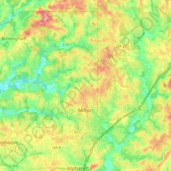
Name: Topografische Karte Milton, Höhe, Relief.
Ort: Milton, Fulton County, Georgia, 30004, United States (34.07717 -84.39658 34.18629 -84.24473)
Durchschnittliche Höhe: 330 m
Minimale Höhe: 284 m
Maximale Höhe: 392 m
According to the U.S. Census Bureau, the city of Milton has a total area of 39.2 square miles (101.4 km2), of which 38.5 square miles (99.8 km2) is land and 0.62 square miles (1.6 km2), or 1.59%, is water. The elevation ranges from 950 to 1,280 feet (290 to 390 m) above sea level.
Andere topografische Karten
Klicken Sie auf eine Karte, um ihre Topografie, ihre Höhe und ihr Relief anzuzeigen.
Roswell
United States > Georgia > Fulton County
Roswell, Fulton County, Georgia, United States
Durchschnittliche Höhe: 316 m
Shandra Estates
United States > Georgia > Fulton County
Shandra Estates, Fulton County, Georgia, 30291, United States
Durchschnittliche Höhe: 289 m
Union City
United States > Georgia > Fulton County
Union City, Fulton County, Georgia, United States
Durchschnittliche Höhe: 284 m
Shake Rag
United States > Georgia > Fulton County > Johns Creek
Shake Rag, Johns Creek, Fulton County, Georgia, 30095, United States
Durchschnittliche Höhe: 300 m
Bamboo Forest
United States > Georgia > Fulton County > Sandy Springs
Bamboo Forest, Sandy Springs, Fulton County, Georgia, 30339, United States
Durchschnittliche Höhe: 278 m
Atlanta
United States > Georgia > Fulton County
Atlanta, Fulton County, Georgia, United States
Durchschnittliche Höhe: 284 m
Sandy Springs
United States > Georgia > Fulton County
Sandy Springs, Fulton County, Georgia, United States
Durchschnittliche Höhe: 301 m
South Fulton
United States > Georgia > Fulton County
South Fulton, Fulton County, Georgia, United States
Durchschnittliche Höhe: 272 m
Chattahoochee Hills
United States > Georgia > Fulton County
Chattahoochee Hills, Fulton County, Georgia, United States
Durchschnittliche Höhe: 261 m
Piedmont Park
United States > Georgia > Fulton County > Atlanta
Piedmont Park, Atlanta, Fulton County, Georgia, 30306, United States
Durchschnittliche Höhe: 283 m
Boulder Park
United States > Georgia > Fulton County > Atlanta
Boulder Park, Atlanta, Fulton County, Georgia, 30336, United States
Durchschnittliche Höhe: 257 m
East Point
United States > Georgia > Fulton County
East Point, Fulton County, Georgia, 30344, United States
Durchschnittliche Höhe: 295 m
Atlanta
United States > Georgia > Fulton County
Atlanta, Fulton County, Georgia, 30303, United States
Durchschnittliche Höhe: 285 m
Johns Creek
United States > Georgia > Fulton County > Johns Creek > Johns Creek
Johns Creek, Fulton County, Georgia, 30097, United States
Durchschnittliche Höhe: 305 m
Roswell
United States > Georgia > Fulton County > Roswell
Roswell, Fulton County, Georgia, 30077, United States
Durchschnittliche Höhe: 312 m
Alpharetta
United States > Georgia > Fulton County > Alpharetta
Alpharetta, Fulton County, Georgia, 300009, United States
Durchschnittliche Höhe: 325 m
Johns Creek
United States > Georgia > Fulton County > Johns Creek
Johns Creek, Fulton County, Georgia, 30097, United States
Durchschnittliche Höhe: 314 m
Johns Creek
United States > Georgia > Fulton County
Johns Creek, Fulton County, Georgia, United States
Durchschnittliche Höhe: 314 m
Simsville
United States > Georgia > Fulton County > Atlanta > Simsville
Simsville, Atlanta, Fulton County, Georgia, 30318, United States
Durchschnittliche Höhe: 275 m
Alpharetta
United States > Georgia > Fulton County
Alpharetta, Fulton County, Georgia, United States
Durchschnittliche Höhe: 324 m
Mountain Park
United States > Georgia > Fulton County
Mountain Park, Fulton County, Georgia, United States
Durchschnittliche Höhe: 312 m
Palmetto
United States > Georgia > Fulton County
Palmetto, Fulton County, Georgia, 30268, United States
Durchschnittliche Höhe: 291 m