
Topografische Karte Sharpsburg
Interaktive Karte
Klicken Sie auf die Karte, um die Höhe anzuzeigen.
Über diese Karte
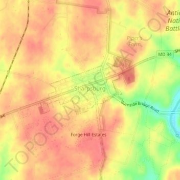
Name: Topografische Karte Sharpsburg, Höhe, Relief.
Ort: Sharpsburg, Washington County, Maryland, United States (39.45365 -77.75863 39.46101 -77.74239)
Durchschnittliche Höhe: 138 m
Minimale Höhe: 95 m
Maximale Höhe: 156 m
Andere topografische Karten
Klicken Sie auf eine Karte, um ihre Topografie, ihre Höhe und ihr Relief anzuzeigen.
Weverton
United States > Maryland > Washington County
Weverton, Washington County, Maryland, 21758, United States
Durchschnittliche Höhe: 153 m
Hancock
United States > Maryland > Washington County
Hancock, Washington County, Maryland, United States
Durchschnittliche Höhe: 167 m
Hancock
United States > Maryland > Washington County > Hancock > Hancock
Hancock, Washington County, Maryland, 21750, United States
Durchschnittliche Höhe: 166 m
Keedysville
United States > Maryland > Washington County > Keedysville
Keedysville, Washington County, Maryland, United States
Durchschnittliche Höhe: 129 m
Hagerstown
United States > Maryland > Washington County
Hagerstown, Washington County, Maryland, United States
Durchschnittliche Höhe: 170 m