
Topografische Karte Obando
Interaktive Karte
Klicken Sie auf die Karte, um die Höhe anzuzeigen.
Über diese Karte
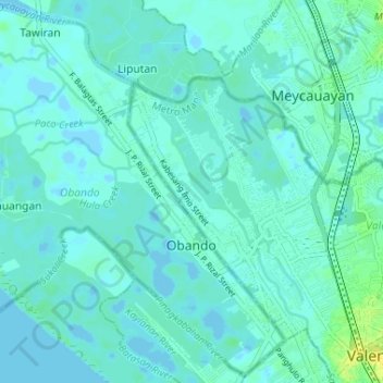
Name: Topografische Karte Obando, Höhe, Relief.
Ort: Obando, Bulacan, Central Luzon, 3021, Philippines (14.68790 120.88753 14.74941 120.95245)
Durchschnittliche Höhe: 2 m
Minimale Höhe: -4 m
Maximale Höhe: 8 m
Flat and low-lying coastal plains characterize the general topography of Obando. The area was formerly an estuary, but it filled up partially from the peripheral parts of each sand bar and sand spit and formed up into current figure that mainly consisted of commercial district, partly industrial district, residential area and fishpond. Within the municipality are two rivers and three creeks namely Meycauayan River, in the north, Pinagkabalian River, in the south and Paco Creek, Hulo Creek and Pag-asa Creek traversing the town parallel to the provincial road.