
Topografische Karte Landican
Interaktive Karte
Klicken Sie auf die Karte, um die Höhe anzuzeigen.
Über diese Karte
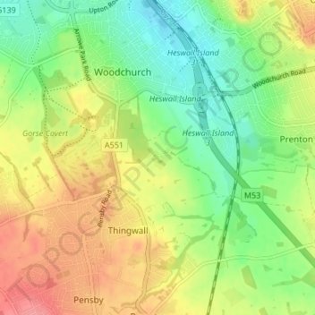
Name: Topografische Karte Landican, Höhe, Relief.
Durchschnittliche Höhe: 45 m
Minimale Höhe: 10 m
Maximale Höhe: 87 m
Landican is in the central part of the Wirral Peninsula, approximately 6 km (3.7 mi) south-south-east of the Irish Sea at Leasowe Lighthouse, 5 km (3.1 mi) east-north-east of the Dee Estuary at Thurstaston and 5 km (3.1 mi) west-south-west of the River Mersey at Tranmere Oil Terminal. Landican is situated between Thurstaston Hill and the Bidston to Storeton ridge, with the centre of the hamlet at an elevation of about 44 m (144 ft) above sea level.