
Topografische Karte Taylorsville
Interaktive Karte
Klicken Sie auf die Karte, um die Höhe anzuzeigen.
Taylorsville
The land on which Taylorsville is located is part of an interconnected alluvial plain that was formed by the wearing down of the Wasatch and Oquirrh Mountains to the east and west. Beneath the surface, Taylorsville sits on more than a kilometer of unconsolidated rock, sand, and clay. The inactive Taylorsville Fault has been traced down the center of the Salt Lake Valley. Lake Bonneville shaped the topography of the area and deposited lake bottom clay and sand. As Lake Bonneville dried up over the past 14,000 years, the salt from the breakdown of rock remains, making the soil alkaline. Like most desert soils, it has little organic material and is hard to work.
Über diese Karte
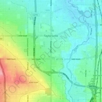
Name: Topografische Karte Taylorsville, Höhe, Relief.
Ort: Taylorsville, Salt Lake County, Utah, United States (40.62985 -111.99155 40.68633 -111.90783)
Durchschnittliche Höhe: 1.325 m
Minimale Höhe: 1.293 m
Maximale Höhe: 1.410 m
Andere topografische Karten
Klicken Sie auf eine Karte, um ihre Topografie, ihre Höhe und ihr Relief anzuzeigen.
Salt Lake City
United States > Utah > Salt Lake County > Salt Lake City
Salt Lake City has an area of 110.4 square miles (286 km2) and an average elevation of 4,327 feet (1,319 m) above sea level. The lowest point within the boundaries of the city is 4,210 feet (1,280 m) near the Jordan River and the Great Salt Lake, and the highest is Grandview Peak, at 9,410 feet (2,868 m).
Durchschnittliche Höhe: 1.625 m
Draper Commercial Parkway
United States > Utah > Salt Lake County > Draper
Durchschnittliche Höhe: 1.355 m
Bellwood Acres
United States > Utah > Salt Lake County > Cottonwood Heights
Durchschnittliche Höhe: 1.398 m
Brighton
United States > Utah > Salt Lake County
Brighton has a high-altitude cold continental climate (Köppen Dsb/Dsc), with dry summers and very snowy winters.
Durchschnittliche Höhe: 2.852 m
South Valence Drainage
United States > Utah > Salt Lake County > West Jordan
Durchschnittliche Höhe: 1.388 m