
Topografische Karte Errenteria
Interaktive Karte
Klicken Sie auf die Karte, um die Höhe anzuzeigen.
Über diese Karte
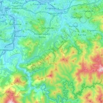
Name: Topografische Karte Errenteria, Höhe, Relief.
Durchschnittliche Höhe: 190 m
Minimale Höhe: -2 m
Maximale Höhe: 781 m
Andere topografische Karten
Klicken Sie auf eine Karte, um ihre Topografie, ihre Höhe und ihr Relief anzuzeigen.
Oiartzun
Spain > Autonomous Community of the Basque Country > Donostialdea
Oiartzun, Donostialdea, Gipuzkoa, Autonomous Community of the Basque Country, 20180, Spain
Durchschnittliche Höhe: 251 m
Pasaia
Spain > Autonomous Community of the Basque Country > Donostialdea
Pasaia, Donostialdea, Gipuzkoa, Autonomous Community of the Basque Country, 20110, Spain
Durchschnittliche Höhe: 40 m
Donostia / San Sebastián
Spain > Autonomous Community of the Basque Country > Donostialdea > Donostia / San Sebastián
Donostia / San Sebastián, San Sebastián, Donostialdea, Gipuzkoa, Autonomous Community of the Basque Country, 20003, Spain
Durchschnittliche Höhe: 134 m
Zikuñaga
Spain > Autonomous Community of the Basque Country > Donostialdea > Hernani > Zikuñaga
Zikuñaga, Hernani, Donostialdea, Gipuzkoa, Autonomous Community of the Basque Country, 20120, Spain
Durchschnittliche Höhe: 62 m
Usurbil
Spain > Autonomous Community of the Basque Country > Donostialdea
Usurbil, Donostialdea, Gipuzkoa, Autonomous Community of the Basque Country, 20170, Spain
Durchschnittliche Höhe: 138 m