
Topografische Karte Fairway Rock
Interaktive Karte
Klicken Sie auf die Karte, um die Höhe anzuzeigen.
Über diese Karte
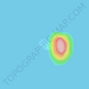
Name: Topografische Karte Fairway Rock, Höhe, Relief.
Ort: Fairway Rock, Unorganized Borough, Alaska, United States (65.62328 -168.74662 65.62673 -168.73704)
Durchschnittliche Höhe: 7 m
Minimale Höhe: -3 m
Maximale Höhe: 159 m
Fairway Rock lies inside Alaska's Nome Census Area and Alaska Department of Fish and Game Wildlife Conservation Unit 22E. It is conveyed to Inalik Native Corporation. Fairway Rock appears on United States Geological Survey topographic maps in the Teller Quadrangle.
Andere topografische Karten
Klicken Sie auf eine Karte, um ihre Topografie, ihre Höhe und ihr Relief anzuzeigen.
Besboro Island
United States > Alaska > Unorganized Borough
Besboro Island, Unorganized Borough, Alaska, United States
Durchschnittliche Höhe: 28 m
Hoonah
United States > Alaska > Unorganized Borough
Hoonah, Unorganized Borough, Alaska, 99829, United States
Durchschnittliche Höhe: 109 m
Central
United States > Alaska > Unorganized Borough
Central, Unorganized Borough, Alaska, United States
Durchschnittliche Höhe: 482 m
Tundra
United States > Alaska > Unorganized Borough
Tundra, Unorganized Borough, Alaska, United States
Durchschnittliche Höhe: 13 m
Madre de Dios Island
United States > Alaska > Unorganized Borough
Madre de Dios Island, Unorganized Borough, Alaska, United States
Durchschnittliche Höhe: 12 m
Saint Paul Island
United States > Alaska > Unorganized Borough > St. Paul
Saint Paul Island, St. Paul, Unorganized Borough, Alaska, 99660, United States
Durchschnittliche Höhe: 10 m
O'Brien Creek
United States > Alaska > Unorganized Borough
O'Brien Creek, Unorganized Borough, Alaska, United States
Durchschnittliche Höhe: 753 m
Prospect Creek
United States > Alaska > Unorganized Borough
Prospect Creek, Unorganized Borough, Alaska, United States
Durchschnittliche Höhe: 420 m
Dry Creek
United States > Alaska > Unorganized Borough
Dry Creek, Unorganized Borough, Alaska, United States
Durchschnittliche Höhe: 915 m
Shaw Island
United States > Alaska > Unorganized Borough
Shaw Island, Unorganized Borough, Alaska, United States
Durchschnittliche Höhe: 169 m
Point Napean
United States > Alaska > Unorganized Borough
Point Napean, Unorganized Borough, Alaska, United States
Durchschnittliche Höhe: 55 m
Pelican
United States > Alaska > Unorganized Borough
Pelican, Unorganized Borough, Alaska, 99832, United States
Durchschnittliche Höhe: 78 m
Twelve
United States > Alaska > Unorganized Borough
Twelve, Unorganized Borough, Alaska, United States
Durchschnittliche Höhe: 1.107 m
Unalaska
United States > Alaska > Unorganized Borough > Unalaska
Unalaska, Unorganized Borough, Alaska, United States
Durchschnittliche Höhe: 132 m
King Island
United States > Alaska > Unorganized Borough
King Island, Unorganized Borough, Alaska, United States
Durchschnittliche Höhe: 60 m
Atka Island
United States > Alaska > Unorganized Borough
Atka Island, Unorganized Borough, Alaska, 99547, United States
Durchschnittliche Höhe: 30 m
Bethel
United States > Alaska > Unorganized Borough
Bethel, Unorganized Borough, Alaska, 99559, United States
Durchschnittliche Höhe: 11 m