
Topografische Karte Ruthin
Interaktive Karte
Klicken Sie auf die Karte, um die Höhe anzuzeigen.
Ruthin
The Myddleton Arms is also known as the Seven Eyes. It is said to have been built in the 14th century. The Dutch style design, long, steeped roof is attributed to Sir Richard Clough, an Elizabethan merchant. It has four tiers of dormer windows, each at a different elevation, known locally as the seven eyes of Ruthin. The property was acquired in 1595 by Sir Hugh Myddleton, who provided London with it first fresh water supply. The view of The Myddleton on the square is in fact of the rear of the building. The front looks out over the Clwydian Hills.
Über diese Karte
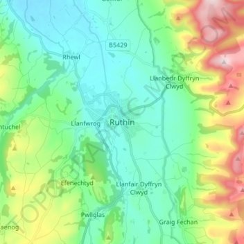
Name: Topografische Karte Ruthin, Höhe, Relief.
Ort: Ruthin, Denbighshire, Wales, LL15 1BU, United Kingdom (53.07155 -3.34524 53.15155 -3.26524)
Durchschnittliche Höhe: 162 m
Minimale Höhe: 35 m
Maximale Höhe: 505 m
Andere topografische Karten
Klicken Sie auf eine Karte, um ihre Topografie, ihre Höhe und ihr Relief anzuzeigen.