
Topografische Karte Lahul and Spiti
Interaktive Karte
Klicken Sie auf die Karte, um die Höhe anzuzeigen.
Über diese Karte
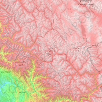
Name: Topografische Karte Lahul and Spiti, Höhe, Relief.
Ort: Lahul and Spiti, Himachal Pradesh, India (31.75233 76.37130 33.25567 78.69266)
Durchschnittliche Höhe: 4.286 m
Minimale Höhe: 519 m
Maximale Höhe: 6.643 m
The two valleys are quite different in character. Spiti is more barren and difficult to cross, with an average elevation of the valley floor of 4,270 m (14,010 ft). It is enclosed between lofty ranges, with the Spiti river rushing out of a gorge in the southeast to meet the Sutlej River. It is a typical mountain desert area with an average annual rainfall of only 170 mm (6.7 in). The district has close cultural links with Ngari Prefecture of Tibet Autonomous Region.
Andere topografische Karten
Klicken Sie auf eine Karte, um ihre Topografie, ihre Höhe und ihr Relief anzuzeigen.
Tosa
India > Himachal Pradesh > Chamba
Tosa, Chamba, Chamba District, Himachal Pradesh, 176319, India
Durchschnittliche Höhe: 1.674 m
Kullu
India > Himachal Pradesh > Kullu
Kullu, Himachal Pradesh, 175100, India
Durchschnittliche Höhe: 1.808 m