
Topografische Karte Kavaratti Island
Interaktive Karte
Klicken Sie auf die Karte, um die Höhe anzuzeigen.
Kavaratti Island
The island of Kavaratti lies 360 km (190 nmi) off the coast of the state of Kerala at 10°34′N 72°38′E / 10.57°N 72.64°E / 10.57; 72.64. It has an average elevation of 0 metres (0 feet).
Über diese Karte
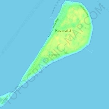
Name: Topografische Karte Kavaratti Island, Höhe, Relief.
Ort: Kavaratti Island, Kavaratti, Lakshadweep, 262240, India (10.54073 72.61545 10.57747 72.64979)
Durchschnittliche Höhe: 2 m
Minimale Höhe: 0 m
Maximale Höhe: 17 m