
Topografische Karte Mason City
Interaktive Karte
Klicken Sie auf die Karte, um die Höhe anzuzeigen.
Über diese Karte
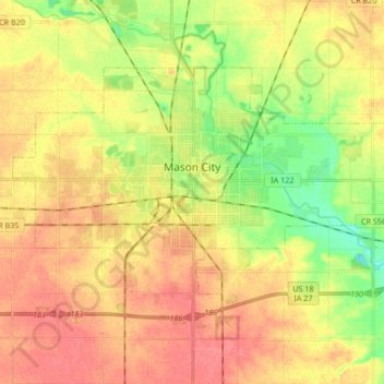
Name: Topografische Karte Mason City, Höhe, Relief.
Ort: Mason City, Cerro Gordo County, Iowa, United States (43.10464 -93.28039 43.18411 -93.11245)
Durchschnittliche Höhe: 352 m
Minimale Höhe: 317 m
Maximale Höhe: 378 m
Andere topografische Karten
Klicken Sie auf eine Karte, um ihre Topografie, ihre Höhe und ihr Relief anzuzeigen.
Rockwell
United States > Iowa > Cerro Gordo County
Rockwell, Cerro Gordo County, Iowa, United States
Durchschnittliche Höhe: 343 m
Clear Lake
United States > Iowa > Cerro Gordo County
Clear Lake, Cerro Gordo County, Iowa, 50428, United States
Durchschnittliche Höhe: 373 m
Clear Lake
United States > Iowa > Cerro Gordo County > Clear Lake > Clear Lake
Clear Lake, Cerro Gordo County, Iowa, 50428, United States
Durchschnittliche Höhe: 373 m