
Spenden
Rüste dich für dein nächstes Abenteuer:
Als Amazon-Partner verdient diese Website an qualifizierten Käufen, ohne zusätzliche Kosten für Sie.
Topografische Karte Gilroy
Klicken Sie auf die Karte, um die Höhe anzuzeigen.
Spenden
Rüste dich für dein nächstes Abenteuer:
Als Amazon-Partner verdient diese Website an qualifizierten Käufen, ohne zusätzliche Kosten für Sie.
Gilroy
Gilroy is approximately 26 km (16 mi) south of San Jose, California (Bailey Avenue (37.206770, -121.729150) to Monterey/Day Road (37.038210, -121.584480)) on U.S. Route 101 and 31 km (19 mi) inland from the Pacific Coast. Despite its apparent close proximity to San Jose, it is important to note that Gilroy City Hall lies at a distance of 33.3 miles from San Jose City Hall. Lying in a southern extension of the Santa Clara Valley at an elevation of about 61 m (200 ft) above MSL, it is bounded by the Santa Cruz Mountains to the west and the Diablo Range to the east. According to the United States Census Bureau, the city has a total area of 16.2 square miles (42 km2). 16.1 square miles (42 km2) of it is land and 0.06% is water.
Spenden
Rüste dich für dein nächstes Abenteuer:
Als Amazon-Partner verdient diese Website an qualifizierten Käufen, ohne zusätzliche Kosten für Sie.
Über diese Karte
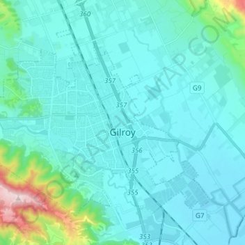
Name: Topografische Karte Gilroy, Höhe, Relief.
Ort: Gilroy, Santa Clara County, California, United States (36.97235 -121.64336 37.04821 -121.51880)
Durchschnittliche Höhe: 107 m
Minimale Höhe: 41 m
Maximale Höhe: 597 m
Spenden
Rüste dich für dein nächstes Abenteuer:
Als Amazon-Partner verdient diese Website an qualifizierten Käufen, ohne zusätzliche Kosten für Sie.
Andere topografische Karten
Klicken Sie auf eine Karte, um ihre Topografie, ihre Höhe und ihr Relief anzuzeigen.
Santa Cruz Mountains
United States > California > Santa Clara County
The Santa Cruz Mountains are a region of great biological diversity, encompassing cool, moist coastal ecosystems as well as warm, dry chaparral. Much of the area in the Santa Cruz mountains is considered temperate rainforest. In valleys and moist ocean-facing slopes some of the southernmost coast redwoods…
Durchschnittliche Höhe: 230 m
Silicon Valley
United States > California > Santa Clara County > Palo Alto
Durchschnittliche Höhe: 118 m
Belgatos Park
United States > California > Santa Clara County > Los Gatos
Durchschnittliche Höhe: 130 m
Spenden
Rüste dich für dein nächstes Abenteuer:
Als Amazon-Partner verdient diese Website an qualifizierten Käufen, ohne zusätzliche Kosten für Sie.
Santa Cruz Mountains
United States > California > Santa Clara County
The Santa Cruz Mountains are a region of great biological diversity, encompassing cool, moist coastal ecosystems as well as warm, dry chaparral. Much of the area in the Santa Cruz mountains is temperate rainforest. In valleys and moist ocean-facing slopes some of the southernmost coast redwoods grow, along…
Durchschnittliche Höhe: 230 m
Alum Rock Park
United States > California > Santa Clara County > San Jose
Durchschnittliche Höhe: 367 m
Spenden
Rüste dich für dein nächstes Abenteuer:
Als Amazon-Partner verdient diese Website an qualifizierten Käufen, ohne zusätzliche Kosten für Sie.
Silicon Valley
United States > California > Santa Clara County > Palo Alto
Durchschnittliche Höhe: 118 m
Spenden
Rüste dich für dein nächstes Abenteuer:
Als Amazon-Partner verdient diese Website an qualifizierten Käufen, ohne zusätzliche Kosten für Sie.
Morgan Hill
United States > California > Santa Clara County > Morgan Hill
Morgan Hill is approximately 39 km (24 mi) south of downtown San Jose, 21 km (13 mi) north of Gilroy, and 24 km (15 mi) inland from the Pacific coast. Lying in a roughly 6 km-wide (4-mi-wide) southern extension of the Santa Clara Valley, it is bounded by the Santa Cruz Mountains to the west and the Diablo…
Durchschnittliche Höhe: 145 m
Seven Springs
United States > California > Santa Clara County > Cupertino
Durchschnittliche Höhe: 127 m
Spenden
Rüste dich für dein nächstes Abenteuer:
Als Amazon-Partner verdient diese Website an qualifizierten Käufen, ohne zusätzliche Kosten für Sie.
Lone Hill Park
United States > California > Santa Clara County > San Jose
Durchschnittliche Höhe: 72 m
Spenden
Rüste dich für dein nächstes Abenteuer:
Als Amazon-Partner verdient diese Website an qualifizierten Käufen, ohne zusätzliche Kosten für Sie.
Calero 72-003 Dam
United States > California > Santa Clara County > San Jose
Durchschnittliche Höhe: 187 m
Pacheco Pass
United States > California > Santa Clara County
Pacheco Pass, elevation 1,368 ft (417 m), is a low mountain pass located in the Diablo Range in southeastern Santa Clara County, California. It is the main route through the hills separating the Santa Clara Valley and the Central Valley.
Durchschnittliche Höhe: 425 m
Spenden
Rüste dich für dein nächstes Abenteuer:
Als Amazon-Partner verdient diese Website an qualifizierten Käufen, ohne zusätzliche Kosten für Sie.
Sandy Wool Lake
United States > California > Santa Clara County > Milpitas
Durchschnittliche Höhe: 232 m
Vasona Lake County Park
United States > California > Santa Clara County > Los Gatos > Shannon
Durchschnittliche Höhe: 109 m
Creekside Village
United States > California > Santa Clara County > Los Gatos
Durchschnittliche Höhe: 166 m
Spenden
Rüste dich für dein nächstes Abenteuer:
Als Amazon-Partner verdient diese Website an qualifizierten Käufen, ohne zusätzliche Kosten für Sie.
Coyote
United States > California > Santa Clara County
Due to the moderating influence of the Pacific Ocean, Coyote enjoys a mild, Mediterranean climate. Temperatures range from an average midsummer maximum of 32.3°C (90.2°F) to an average midwinter low of 0.9 °C (33.6 °F). Average annual precipitation is 480 mm (18.9 in), and the summer months are typically…
Durchschnittliche Höhe: 131 m
Holy City
United States > California > Santa Clara County > Redwood Estates
Durchschnittliche Höhe: 429 m
Spenden
Rüste dich für dein nächstes Abenteuer:
Als Amazon-Partner verdient diese Website an qualifizierten Käufen, ohne zusätzliche Kosten für Sie.
Silicon Valley
United States > California > Santa Clara County > Palo Alto
Durchschnittliche Höhe: 118 m
Lexington Hills
United States > California > Santa Clara County > Redwood Estates
Durchschnittliche Höhe: 424 m
Spenden
Rüste dich für dein nächstes Abenteuer:
Als Amazon-Partner verdient diese Website an qualifizierten Käufen, ohne zusätzliche Kosten für Sie.
Los Altos Hills
United States > California > Santa Clara County > Los Altos Hills > Los Altos Hills
Durchschnittliche Höhe: 94 m
Spenden
Rüste dich für dein nächstes Abenteuer:
Als Amazon-Partner verdient diese Website an qualifizierten Käufen, ohne zusätzliche Kosten für Sie.