
Spenden
Rüste dich für dein nächstes Abenteuer:
Als Amazon-Partner verdient diese Website an qualifizierten Käufen, ohne zusätzliche Kosten für Sie.
Topografische Karte Frogholt
Klicken Sie auf die Karte, um die Höhe anzuzeigen.
Spenden
Rüste dich für dein nächstes Abenteuer:
Als Amazon-Partner verdient diese Website an qualifizierten Käufen, ohne zusätzliche Kosten für Sie.
Über diese Karte
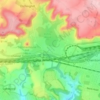
Name: Topografische Karte Frogholt, Höhe, Relief.
Durchschnittliche Höhe: 93 m
Minimale Höhe: 13 m
Maximale Höhe: 188 m
Spenden
Rüste dich für dein nächstes Abenteuer:
Als Amazon-Partner verdient diese Website an qualifizierten Käufen, ohne zusätzliche Kosten für Sie.
Andere topografische Karten
Klicken Sie auf eine Karte, um ihre Topografie, ihre Höhe und ihr Relief anzuzeigen.
Folkestone
United Kingdom > England > Kent > Folkestone and Hythe District
Durchschnittliche Höhe: 62 m
Spenden
Rüste dich für dein nächstes Abenteuer:
Als Amazon-Partner verdient diese Website an qualifizierten Käufen, ohne zusätzliche Kosten für Sie.
Hawkinge
United Kingdom > England > Kent > Folkestone and Hythe District
Durchschnittliche Höhe: 140 m
New Romney
United Kingdom > England > Kent > Folkestone and Hythe District
Durchschnittliche Höhe: 2 m
Spenden
Rüste dich für dein nächstes Abenteuer:
Als Amazon-Partner verdient diese Website an qualifizierten Käufen, ohne zusätzliche Kosten für Sie.
Stelling Minnis
United Kingdom > England > Kent > Folkestone and Hythe District
Durchschnittliche Höhe: 135 m
Newington
United Kingdom > England > Kent > Folkestone and Hythe District
Durchschnittliche Höhe: 112 m
Postling
United Kingdom > England > Kent > Folkestone and Hythe District
Durchschnittliche Höhe: 112 m
Spenden
Rüste dich für dein nächstes Abenteuer:
Als Amazon-Partner verdient diese Website an qualifizierten Käufen, ohne zusätzliche Kosten für Sie.
Elmsted
United Kingdom > England > Kent > Folkestone and Hythe District > Lymbridge Green
Durchschnittliche Höhe: 144 m
Stowting
United Kingdom > England > Kent > Folkestone and Hythe District
Durchschnittliche Höhe: 148 m
Greatstone beach
United Kingdom > England > Kent > Folkestone and Hythe District > New Romney > Littlestone on Sea
Durchschnittliche Höhe: 2 m
Spenden
Rüste dich für dein nächstes Abenteuer:
Als Amazon-Partner verdient diese Website an qualifizierten Käufen, ohne zusätzliche Kosten für Sie.
Paddlesworth
United Kingdom > England > Kent > Folkestone and Hythe District
Durchschnittliche Höhe: 161 m
Spenden
Rüste dich für dein nächstes Abenteuer:
Als Amazon-Partner verdient diese Website an qualifizierten Käufen, ohne zusätzliche Kosten für Sie.
St. Mary in the Marsh
United Kingdom > England > Kent > Folkestone and Hythe District
Durchschnittliche Höhe: 2 m
Spenden
Rüste dich für dein nächstes Abenteuer:
Als Amazon-Partner verdient diese Website an qualifizierten Käufen, ohne zusätzliche Kosten für Sie.
Sellindge
United Kingdom > England > Kent > Folkestone and Hythe District
Durchschnittliche Höhe: 71 m
Monks Horton
United Kingdom > England > Kent > Folkestone and Hythe District
Durchschnittliche Höhe: 104 m
Spenden
Rüste dich für dein nächstes Abenteuer:
Als Amazon-Partner verdient diese Website an qualifizierten Käufen, ohne zusätzliche Kosten für Sie.
Folkestone
United Kingdom > England > Kent > Folkestone and Hythe District
Durchschnittliche Höhe: 62 m
Folkestone
United Kingdom > England > Kent > Folkestone and Hythe District
Durchschnittliche Höhe: 62 m
Spenden
Rüste dich für dein nächstes Abenteuer:
Als Amazon-Partner verdient diese Website an qualifizierten Käufen, ohne zusätzliche Kosten für Sie.
Old Romney
United Kingdom > England > Kent > Folkestone and Hythe District
Durchschnittliche Höhe: 2 m
Folkestone
United Kingdom > England > Kent > Folkestone and Hythe District
Durchschnittliche Höhe: 62 m
Newington
United Kingdom > England > Kent > Folkestone and Hythe District
Durchschnittliche Höhe: 112 m
Spenden
Rüste dich für dein nächstes Abenteuer:
Als Amazon-Partner verdient diese Website an qualifizierten Käufen, ohne zusätzliche Kosten für Sie.
Folkestone
United Kingdom > England > Kent > Folkestone and Hythe District
Durchschnittliche Höhe: 62 m
Sellindge
United Kingdom > England > Kent > Folkestone and Hythe District
Durchschnittliche Höhe: 71 m
Folkestone
United Kingdom > England > Kent > Folkestone and Hythe District
Durchschnittliche Höhe: 62 m
Spenden
Rüste dich für dein nächstes Abenteuer:
Als Amazon-Partner verdient diese Website an qualifizierten Käufen, ohne zusätzliche Kosten für Sie.
New Romney
United Kingdom > England > Kent > Folkestone and Hythe District
Durchschnittliche Höhe: 2 m