
Topografische Karte Lawrence
Interaktive Karte
Klicken Sie auf die Karte, um die Höhe anzuzeigen.
Über diese Karte
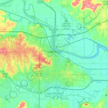
Name: Topografische Karte Lawrence, Höhe, Relief.
Ort: Lawrence, Douglas County, Kansas, United States (38.90447 -95.34454 39.03350 -95.16662)
Durchschnittliche Höhe: 265 m
Minimale Höhe: 241 m
Maximale Höhe: 333 m
Lawrence is located at coordinates 38.9716689, -95.2352501 in the state of Kansas, approximately 25 miles (40 kilometers) east of Topeka, and 35 mi (56 km) west of Kansas City, Kansas. Though Lawrence has a designated elevation of 866 feet (264 m), the highest elevation is Mount Oread on the University of Kansas campus with an elevation of 1,020 feet (310 m).
Andere topografische Karten
Klicken Sie auf eine Karte, um ihre Topografie, ihre Höhe und ihr Relief anzuzeigen.
Baldwin City
United States > Kansas > Douglas County
Baldwin City, Douglas County, Kansas, United States
Durchschnittliche Höhe: 323 m
Lecompton
United States > Kansas > Douglas County
Lecompton, Douglas County, Kansas, United States
Durchschnittliche Höhe: 281 m
Lawrence
United States > Kansas > Douglas County > Lawrence
Lawrence, Douglas County, Kansas, 66044, United States
Durchschnittliche Höhe: 283 m
Eudora
United States > Kansas > Douglas County > Eudora > Eudora
Eudora, Douglas County, Kansas, 66025, United States
Durchschnittliche Höhe: 258 m
Overlook Park
United States > Kansas > Douglas County
Overlook Park, Kanwaka Township, Douglas County, Kansas, United States
Durchschnittliche Höhe: 281 m
Burcham Park
United States > Kansas > Douglas County > Lawrence
Burcham Park, Lawrence, Douglas County, Kansas, 66044, United States
Durchschnittliche Höhe: 260 m