
Topografische Karte Mount-Royal
Interaktive Karte
Klicken Sie auf die Karte, um die Höhe anzuzeigen.
Über diese Karte
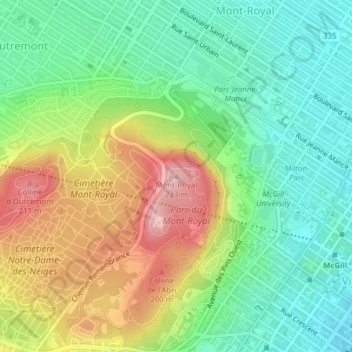
Name: Topografische Karte Mount-Royal, Höhe, Relief.
Durchschnittliche Höhe: 111 m
Minimale Höhe: 35 m
Maximale Höhe: 232 m
The hill is part of the Monteregian Hills situated between the Laurentians and the Appalachian Mountains. It gave its Latin name, Mons Regius, to the Monteregian chain. The hill consists of three peaks: Colline de la Croix (or Mont Royal proper) at 233 m (764 ft), Colline d'Outremont (or Mount Murray, in the borough of Outremont) at 211 m (692 ft), and Westmount Summit at 201 m (659 ft) elevation above mean sea level.
Andere topografische Karten
Klicken Sie auf eine Karte, um ihre Topografie, ihre Höhe und ihr Relief anzuzeigen.
Mount Royal Park
Canada > Quebec > Urban agglomeration of Montreal > Montreal
Mount Royal Park, Ville-Marie, Montreal, Urban agglomeration of Montreal, Montreal (administrative region), Quebec, H3G 1A8, Canada
Durchschnittliche Höhe: 110 m
Parc Marie-Claire-Kirkland-Casgrain
Canada > Quebec > Urban agglomeration of Montreal > Montreal
Parc Marie-Claire-Kirkland-Casgrain, Sault-Saint-Louis, LaSalle, Montreal, Urban agglomeration of Montreal, Montreal (06), Quebec, Canada
Durchschnittliche Höhe: 24 m
Parc-nature de la Pointe-aux-Prairies
Canada > Quebec > Urban agglomeration of Montreal > Montreal
Parc-nature de la Pointe-aux-Prairies, Rue Sherbrooke Est, Pointe-aux-Trembles, Montreal, Urban agglomeration of Montreal, Montreal (06), Quebec, H1A 3R1, Canada
Durchschnittliche Höhe: 13 m