
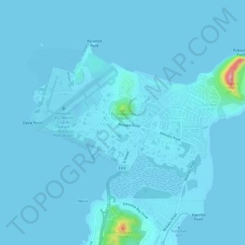
Topografische Karte Marine Corps Base Hawaii Kaneohe
Interaktive Karte
Klicken Sie auf die Karte, um die Höhe anzuzeigen.
Über diese Karte
Name: Topografische Karte Marine Corps Base Hawaii Kaneohe, Höhe, Relief.
Durchschnittliche Höhe: 7 m
Minimale Höhe: -5 m
Maximale Höhe: 198 m
Andere topografische Karten
Klicken Sie auf eine Karte, um ihre Topografie, ihre Höhe und ihr Relief anzuzeigen.
Kapunahala
United States > Hawaii > Honolulu County > Kaneohe
Kapunahala, Kaneohe, Honolulu County, Hawaii, 96744, United States
Durchschnittliche Höhe: 91 m
Kokokahi
United States > Hawaii > Honolulu County > Kaneohe
Kokokahi, Kaneohe, Honolulu County, Hawaii, 96744, United States
Durchschnittliche Höhe: 27 m
Ho'omaluhia Botanical Garden
United States > Hawaii > Honolulu County > Kaneohe > Keapuka
Ho'omaluhia Botanical Garden, Keapuka, Kaneohe, Honolulu County, Hawaii, 96744, United States
Durchschnittliche Höhe: 155 m