
Topografische Karte South Fulton
Interaktive Karte
Klicken Sie auf die Karte, um die Höhe anzuzeigen.
Über diese Karte
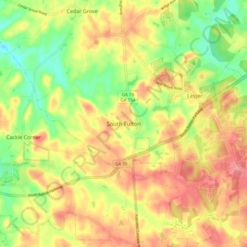
Name: Topografische Karte South Fulton, Höhe, Relief.
Ort: South Fulton, Fulton County, Georgia, United States (33.55027 -84.71123 33.63027 -84.63123)
Durchschnittliche Höhe: 272 m
Minimale Höhe: 220 m
Maximale Höhe: 319 m
Andere topografische Karten
Klicken Sie auf eine Karte, um ihre Topografie, ihre Höhe und ihr Relief anzuzeigen.
Chattahoochee Hills
United States > Georgia > Fulton County
Chattahoochee Hills, Fulton County, Georgia, United States
Durchschnittliche Höhe: 261 m
Atlanta
United States > Georgia > Fulton County
Atlanta, Fulton County, Georgia, 30303, United States
Durchschnittliche Höhe: 285 m
Atlanta
United States > Georgia > Fulton County
Atlanta, Fulton County, Georgia, United States
Durchschnittliche Höhe: 284 m