
Topografische Karte Departamento Veinticinco de Mayo
Interaktive Karte
Klicken Sie auf die Karte, um die Höhe anzuzeigen.
Über diese Karte
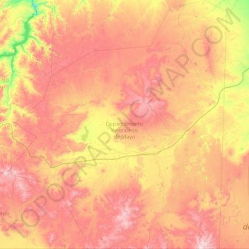
Name: Topografische Karte Departamento Veinticinco de Mayo, Höhe, Relief.
Ort: Departamento Veinticinco de Mayo, Río Negro, Argentina (-41.99205 -70.26982 -40.07321 -68.00858)
Durchschnittliche Höhe: 1.061 m
Minimale Höhe: 477 m
Maximale Höhe: 1.904 m
Andere topografische Karten
Klicken Sie auf eine Karte, um ihre Topografie, ihre Höhe und ihr Relief anzuzeigen.
Municipio de Lamarque
Municipio de Lamarque, Departamento Avellaneda, Río Negro, Argentina
Durchschnittliche Höhe: 131 m
Lago Gutiérrez
Lago Gutiérrez, Ruta Nacional 40, Villa Lago Gutiérrez, Departamento Bariloche, Río Negro, 8400, Argentina
Durchschnittliche Höhe: 1.175 m
General Roca
Argentina > Río Negro > General Roca
General Roca, Departamento General Roca, Río Negro, Argentina
Durchschnittliche Höhe: 246 m
Cinco Saltos
Argentina > Río Negro > Cinco Saltos
Cinco Saltos, Departamento General Roca, Río Negro, 8303, Argentina
Durchschnittliche Höhe: 301 m
San Carlos de Bariloche
San Carlos de Bariloche, Municipio de San Carlos de Bariloche, Departamento Bariloche, Río Negro, 8400, Argentina
Durchschnittliche Höhe: 1.042 m
Pampa Linda
Argentina > Río Negro > Pampa Linda
Pampa Linda, Departamento Bariloche, Río Negro, Argentina
Durchschnittliche Höhe: 1.017 m
Municipio de Viedma
Municipio de Viedma, Departamento Adolfo Alsina, Río Negro, Argentina
Durchschnittliche Höhe: 19 m
Lago Mascardi
Lago Mascardi, Ruta Provincial 81, Departamento Bariloche, Río Negro, Argentina
Durchschnittliche Höhe: 1.090 m