
Topografische Karte Naas
Interaktive Karte
Klicken Sie auf die Karte, um die Höhe anzuzeigen.
Über diese Karte
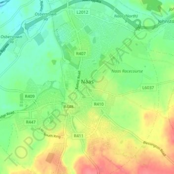
Name: Topografische Karte Naas, Höhe, Relief.
Durchschnittliche Höhe: 97 m
Minimale Höhe: 71 m
Maximale Höhe: 136 m
Andere topografische Karten
Klicken Sie auf eine Karte, um ihre Topografie, ihre Höhe und ihr Relief anzuzeigen.
Newbridge
Newbridge, The Municipal District of Kildare — Newbridge, County Kildare, Leinster, Ireland
Durchschnittliche Höhe: 95 m
Collaghknock Glebe
Collaghknock Glebe, Kildare ED, The Municipal District of Kildare — Newbridge, County Kildare, Leinster, Ireland
Durchschnittliche Höhe: 103 m
Leixlip
Leixlip, The Municipal District of Celbridge — Leixlip, County Kildare, Leinster, Ireland
Durchschnittliche Höhe: 55 m
Newpark
Newpark, Kilmeage South ED, The Municipal District of Clane — Maynooth, County Kildare, Leinster, Ireland
Durchschnittliche Höhe: 87 m
Salt North
Salt North, County Kildare, Leinster, Ireland
Durchschnittliche Höhe: 67 m
Blackford
Blackford, Churchtown ED, The Municipal District of Athy, County Kildare, Leinster, Ireland
Durchschnittliche Höhe: 69 m
Naas
Ireland > County Kildare > Naas
Naas, The Municipal District of Naas, County Kildare, Leinster, Ireland
Durchschnittliche Höhe: 99 m
The Municipal District of Clane — Maynooth
The Municipal District of Clane — Maynooth, County Kildare, Leinster, Ireland
Durchschnittliche Höhe: 86 m
The Municipal District of Naas
The Municipal District of Naas, County Kildare, Leinster, Ireland
Durchschnittliche Höhe: 152 m