
Topografische Karte Kiltegan
Interaktive Karte
Klicken Sie auf die Karte, um die Höhe anzuzeigen.
Über diese Karte
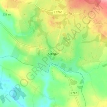
Name: Topografische Karte Kiltegan, Höhe, Relief.
Durchschnittliche Höhe: 150 m
Minimale Höhe: 110 m
Maximale Höhe: 209 m
Andere topografische Karten
Klicken Sie auf eine Karte, um ihre Topografie, ihre Höhe und ihr Relief anzuzeigen.
Upper Lake
Upper Lake, Brockagh ED, The Municipal District of Wicklow, County Wicklow, Leinster, Ireland
Durchschnittliche Höhe: 331 m
The Municipal District of Baltinglass
The Municipal District of Baltinglass, County Wicklow, Leinster, Ireland
Durchschnittliche Höhe: 182 m
Calary
Calary, County Wicklow, Leinster, A98 KN50, Ireland
Durchschnittliche Höhe: 295 m
Enniskerry
Enniskerry, Enniskerry ED, The Municipal District of Bray, County Wicklow, Leinster, Ireland
Durchschnittliche Höhe: 104 m
The Municipal District of Bray
The Municipal District of Bray, County Wicklow, Leinster, Ireland
Durchschnittliche Höhe: 283 m
The Municipal District of Wicklow
The Municipal District of Wicklow, County Wicklow, Leinster, Ireland
Durchschnittliche Höhe: 263 m
Greystones
Ireland > County Wicklow > Greystones
Greystones, The Municipal District of Greystones, County Wicklow, Leinster, A63 HW80, Ireland
Durchschnittliche Höhe: 49 m
Arklow
Arklow, Arklow No 1 Urban ED, The Municipal District of Arklow, County Wicklow, Leinster, Ireland
Durchschnittliche Höhe: 14 m