
Topografische Karte Isla Cozumel
Interaktive Karte
Klicken Sie auf die Karte, um die Höhe anzuzeigen.
Über diese Karte
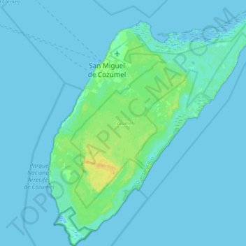
Name: Topografische Karte Isla Cozumel, Höhe, Relief.
Ort: Isla Cozumel, Cozumel, Quintana Roo, Mexico (20.27200 -87.02520 20.59200 -86.72328)
Durchschnittliche Höhe: 2 m
Minimale Höhe: -3 m
Maximale Höhe: 18 m
Large parts of the island are covered with mangrove forest which has many endemic animal species. Cozumel is a flat island based on limestone, resulting in a karst topography. The highest natural point on the island is less than 15 m (49 ft) above sea level. The cenotes are water-filled sinkholes formed by water percolating through the soft limestone soil for thousands of years. Eighteen deep cenotes and more than 250 shallow bodies exist on the island. Many are under dense vegetation. Jade Cavern Cozumel (Cenote Chempita) near El Cedral is often visited by tourists.
Andere topografische Karten
Klicken Sie auf eine Karte, um ihre Topografie, ihre Höhe und ihr Relief anzuzeigen.
Playa Palancar
Mexico > Quintana Roo > Cozumel > Palancar
Playa Palancar, Palancar, Cozumel, Quintana Roo, Mexico
Durchschnittliche Höhe: 1 m