
Topografische Karte Arciprestazgo de Alcalá Sur
Interaktive Karte
Klicken Sie auf die Karte, um die Höhe anzuzeigen.
Arciprestazgo de Alcalá Sur
Standing at an average altitude of 654 m, and occupying some 88 km2; the city was for a long time contained in between the Henares to the South and the Madrid-Barcelona railway to the North. However, the increasing population brought on the sprawl of the urbanised area to the area located in between the railway and the A-2 motorway and beyond.
Über diese Karte
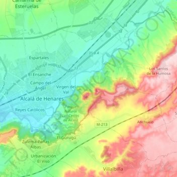
Name: Topografische Karte Arciprestazgo de Alcalá Sur, Höhe, Relief.
Durchschnittliche Höhe: 685 m
Minimale Höhe: 576 m
Maximale Höhe: 899 m