
Topografische Karte Lachung
Interaktive Karte
Klicken Sie auf die Karte, um die Höhe anzuzeigen.
Über diese Karte
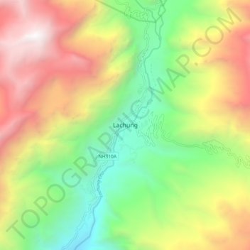
Name: Topografische Karte Lachung, Höhe, Relief.
Ort: Lachung, Chungthang, Mangan District, Sikkim, India (27.64971 88.70259 27.72971 88.78259)
Durchschnittliche Höhe: 3.617 m
Minimale Höhe: 2.281 m
Maximale Höhe: 5.366 m
Lachung is a town and hill station in northeast Sikkim, India. It is located in the North Sikkim district near the border with Tibet. Lachung is at an elevation of about 9,600 feet (2,900 m) and at the confluence of the lachen and Lachung Rivers, both tributaries of the River Teesta. The word Lachung means "small pass". The town is approximately 125 kilometres (78 mi) from the capital Gangtok.
Andere topografische Karten
Klicken Sie auf eine Karte, um ihre Topografie, ihre Höhe und ihr Relief anzuzeigen.
South Lhonak Glacier
India > Sikkim > Chungthang
South Lhonak Glacier, Chungthang, Mangan District, Sikkim, India
Durchschnittliche Höhe: 5.830 m
Lachung Chu
India > Sikkim > Chungthang > Lachung
Lachung Chu, Lachung, Chungthang, North Sikkim District, Sikkim, India
Durchschnittliche Höhe: 4.332 m
Gurudongmar
India > Sikkim > Chungthang
Gurudongmar, Chungthang, North Sikkim District, Sikkim, India
Durchschnittliche Höhe: 5.232 m