
Topografische Karte Live Oak
Interaktive Karte
Klicken Sie auf die Karte, um die Höhe anzuzeigen.
Über diese Karte
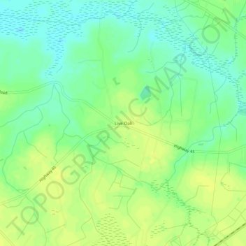
Name: Topografische Karte Live Oak, Höhe, Relief.
Ort: Live Oak, Horry County, South Carolina, 29569, United States (34.03573 -78.95864 34.07573 -78.91864)
Durchschnittliche Höhe: 28 m
Minimale Höhe: 18 m
Maximale Höhe: 36 m
Andere topografische Karten
Klicken Sie auf eine Karte, um ihre Topografie, ihre Höhe und ihr Relief anzuzeigen.
Surfside Beach
United States > South Carolina > Horry County > Surfside Beach
Surfside Beach, Horry County, South Carolina, 29587, United States
Durchschnittliche Höhe: 2 m
Azalea Lakes
United States > South Carolina > Horry County > Socastee
Azalea Lakes, Socastee, Horry County, South Carolina, 29588, United States
Durchschnittliche Höhe: 5 m
Brown Bay
United States > South Carolina > Horry County
Brown Bay, Horry County, South Carolina, United States
Durchschnittliche Höhe: 19 m
North Myrtle Beach
United States > South Carolina > Horry County
North Myrtle Beach, Horry County, South Carolina, United States
Durchschnittliche Höhe: 3 m
Myrtle Beach
United States > South Carolina > Horry County
Myrtle Beach, Horry County, South Carolina, 29577, United States
Durchschnittliche Höhe: 6 m