
Topografische Karte Saint Helens
Interaktive Karte
Klicken Sie auf die Karte, um die Höhe anzuzeigen.
Über diese Karte
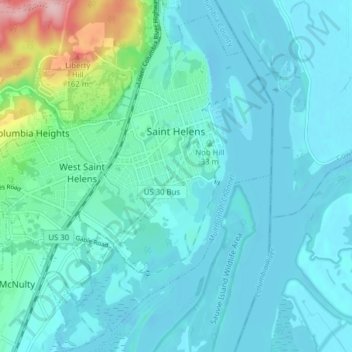
Name: Topografische Karte Saint Helens, Höhe, Relief.
Durchschnittliche Höhe: 27 m
Minimale Höhe: -2 m
Maximale Höhe: 187 m
Andere topografische Karten
Klicken Sie auf eine Karte, um ihre Topografie, ihre Höhe und ihr Relief anzuzeigen.
Warren
United States > Oregon > Columbia County
Warren, Columbia County, Oregon, 97053, United States
Durchschnittliche Höhe: 21 m
Prescott
United States > Oregon > Columbia County
Prescott, Columbia County, Oregon, United States
Durchschnittliche Höhe: 40 m
Vernonia
United States > Oregon > Columbia County
Vernonia, Columbia County, Oregon, United States
Durchschnittliche Höhe: 218 m
Scappoose
United States > Oregon > Columbia County
Scappoose, Columbia County, Oregon, United States
Durchschnittliche Höhe: 31 m
Beaver Springs
United States > Oregon > Columbia County
Beaver Springs, Columbia County, Oregon, United States
Durchschnittliche Höhe: 251 m
Abernathy Creek
United States > Oregon > Columbia County
Abernathy Creek, Columbia County, Oregon, United States
Durchschnittliche Höhe: 38 m
Clatskanie
United States > Oregon > Columbia County
Clatskanie, Columbia County, Oregon, United States
Durchschnittliche Höhe: 46 m
Warren
United States > Oregon > Columbia County
Warren, Columbia County, Oregon, 97053, United States
Durchschnittliche Höhe: 22 m
Columbia City
United States > Oregon > Columbia County
Columbia City, Columbia County, Oregon, 97018, United States
Durchschnittliche Höhe: 34 m
Deer Island
United States > Oregon > Columbia County
Deer Island, Columbia County, Oregon, United States
Durchschnittliche Höhe: 46 m
Rainier
United States > Oregon > Columbia County
Rainier, Columbia County, Oregon, United States
Durchschnittliche Höhe: 123 m