
Topografische Karte Dry Falls
Interaktive Karte
Klicken Sie auf die Karte, um die Höhe anzuzeigen.
Über diese Karte
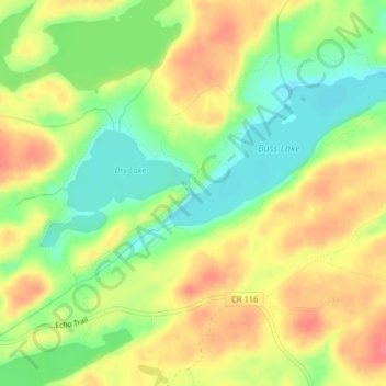
Name: Topografische Karte Dry Falls, Höhe, Relief.
Ort: Dry Falls, Saint Louis County, Minnesota, USA (47.95760 -91.86405 47.95770 -91.86395)
Durchschnittliche Höhe: 442 m
Minimale Höhe: 409 m
Maximale Höhe: 474 m
Andere topografische Karten
Klicken Sie auf eine Karte, um ihre Topografie, ihre Höhe und ihr Relief anzuzeigen.
Lake Vermilion
Lake Vermilion, Frazer Bay Road, Saint Louis County, Minnesota, 55723, USA
Durchschnittliche Höhe: 426 m
Ancient River Warren Channel (historical)
Ancient River Warren Channel (historical), Traverse County, Minnesota, USA
Durchschnittliche Höhe: 313 m
River Valley
USA > Minnesota > River Valley
River Valley, Pennington County, Minnesota, USA
Durchschnittliche Höhe: 353 m
Bde Maka Ska
USA > Minnesota > Minneapolis
Bde Maka Ska, Lake Calhoun Bike Trail, West Calhoun, Minneapolis, Hennepin County, Minnesota, MN, USA
Durchschnittliche Höhe: 267 m
Pomme de Terre Lake
Pomme de Terre Lake, T-205, Grant County, Minnesota, USA
Durchschnittliche Höhe: 366 m
Four Corners
USA > Minnesota > Four Corners
Four Corners, Saint Louis County, Minnesota, USA
Durchschnittliche Höhe: 438 m
Minnehaha Regional Park
USA > Minnesota > Minneapolis
Minnehaha Regional Park, Hiawatha, Minneapolis, Hennepin County, Minnesota, USA
Durchschnittliche Höhe: 249 m
Split Rock Lighthouse
Split Rock Lighthouse, Superior Hiking Trail, Lake County, Minnesota, USA
Durchschnittliche Höhe: 203 m
Steamboat Lake
Steamboat Lake, 435th Street, Aitkin County, Minnesota, 55760, USA
Durchschnittliche Höhe: 377 m
Como Lake
USA > Minnesota > Saint Paul
Como Lake, Horton Avenue, Saint Paul, Ramsey County, Minnesota, 55103, USA
Durchschnittliche Höhe: 280 m
Montrose Manor Mobile Home Park
USA > Minnesota > Montrose Manor Mobile Home Park
Montrose Manor Mobile Home Park, Wright County, Minnesota, 55363, USA
Durchschnittliche Höhe: 295 m
Sand Prairie WMA
USA > Minnesota > Clear Lake
Sand Prairie WMA, US 10, Clear Lake, Sherburne County, Minnesota, 56304, USA
Durchschnittliche Höhe: 316 m
Lake Carlos
USA > Minnesota > Hiview Park
Lake Carlos, East Lake Carlos Drive Northeast, Hiview Park, Douglas County, Minnesota, 56319, USA
Durchschnittliche Höhe: 421 m
Point Douglas
USA > Minnesota > Point Douglas
Point Douglas, Washington County, Minnesota, WI - 54021, USA
Durchschnittliche Höhe: 229 m
Okamanpeedan Lake
Okamanpeedan Lake, 17th Street, Wilbert, Martin County, Minnesota, 56121, USA
Durchschnittliche Höhe: 379 m
Heron Lake
USA > Minnesota > Heron Lake
Heron Lake, Jackson County, Minnesota, 56137, USA
Durchschnittliche Höhe: 432 m
Merden Lake
USA > Minnesota > Jacobs Prairie
Merden Lake, County Road 160, Jacobs Prairie, Stearns County, Minnesota, 56374, USA
Durchschnittliche Höhe: 360 m
Swollen Ankle Lake
Swollen Ankle Lake, Forest Rt 1344, Cook County, Minnesota, USA
Durchschnittliche Höhe: 555 m
Zippel Bay
Zippel Bay, Bay Drive Northwest, Lake of the Woods County, Minnesota, 56686, USA
Durchschnittliche Höhe: 323 m
Lake Cornelia
Lake Cornelia, Edina, Hennepin County, Minnesota, 55435, USA
Durchschnittliche Höhe: 269 m
Greenleaf Lake
Greenleaf Lake, 640th Avenue, Greenleaf, Meeker County, Minnesota, 55324, USA
Durchschnittliche Höhe: 335 m
Ojibway Park
Ojibway Park, Woodbury, Washington County, Minnesota, USA
Durchschnittliche Höhe: 312 m
Mystery Cave State Park
Mystery Cave State Park, Etna, Fillmore County, Minnesota, USA
Durchschnittliche Höhe: 401 m
Spring Park Bay
Spring Park Bay, Wilshire Boulevard, Mound, Hennepin County, Minnesota, 55364, USA
Durchschnittliche Höhe: 286 m
Wenonah
USA > Minnesota > Minneapolis
Wenonah, Minneapolis, Hennepin County, Minnesota, USA
Durchschnittliche Höhe: 255 m
Springbrook Nature Center
Springbrook Nature Center, Fridley, Anoka County, Minnesota, USA
Durchschnittliche Höhe: 267 m
Temperance River
Temperance River, Cook County, Minnesota, USA
Durchschnittliche Höhe: 570 m
Westwood Hills Nature Center
USA > Minnesota > St. Louis Park
Westwood Hills Nature Center, Westwood Hills, St. Louis Park, Hennepin County, Minnesota, USA
Durchschnittliche Höhe: 279 m
Hiawatha
USA > Minnesota > Minneapolis
Hiawatha, Minneapolis, Hennepin County, Minnesota, USA
Durchschnittliche Höhe: 249 m
Keewaydin
USA > Minnesota > Minneapolis
Keewaydin, Minneapolis, Hennepin County, Minnesota, 55417, USA
Durchschnittliche Höhe: 255 m
Judge C. R. Magney State Park
Judge C. R. Magney State Park, Cook County, Minnesota, USA
Durchschnittliche Höhe: 349 m
LaSalle Lake
LaSalle Lake, CR 9, Becida, Hubbard County, Minnesota, 56678, USA
Durchschnittliche Höhe: 449 m
Big Basswood Lake
Big Basswood Lake, Sockeye Lake Road, Becker County, Minnesota, 56575, USA
Durchschnittliche Höhe: 479 m
Tamarack Nature Preserve
Tamarack Nature Preserve, Woodbury, Washington County, Minnesota, USA
Durchschnittliche Höhe: 314 m
Clearwater River
Clearwater River, Meeker County, Minnesota, 55389, USA
Durchschnittliche Höhe: 353 m
Little Pine River
Little Pine River, Crow Wing County, Minnesota, USA
Durchschnittliche Höhe: 376 m
Atkinson Lake
Atkinson Lake, 608th Avenue, Greenleaf, Meeker County, Minnesota, 55355, USA
Durchschnittliche Höhe: 336 m
Howe
USA > Minnesota > Minneapolis
Howe, Minneapolis, Hennepin County, Minnesota, 55406, USA
Durchschnittliche Höhe: 251 m
Saint Louis Bay
Saint Louis Bay, Courtland Street, Duluth, Saint Louis County, Minnesota, 55806, USA
Durchschnittliche Höhe: 186 m