
Topografische Karte Winter Park
Interaktive Karte
Klicken Sie auf die Karte, um die Höhe anzuzeigen.
Winter Park
Its elevation ranges from approximately 8,700 to 12,060 feet (2,650 to 3,680 m) above sea level, and is considered sub-alpine country. It is snow-covered for about six months a year. Although the town center is at about 9,000 feet (2,700 m) above sea level, Winter Park, using administrative boundaries as a measure, became the highest incorporated town in the United States after the July 2006 annexation of 5,214 acres (21.10 km2) of Winter Park Resort to allow new on-mountain improvements. This claim is disputed since Winter Park has no residences above 9,550 feet (2,910 m), while contiguous residential neighborhoods in Leadville, Colorado, extend to 10,360 feet (3,160 m) and in Alma, Colorado, to 11,680 feet (3,560 m), and Alma's town center is at 10,361 feet (3,158 m).
Über diese Karte
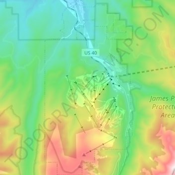
Name: Topografische Karte Winter Park, Höhe, Relief.
Ort: Winter Park, Grand County, Colorado, United States (39.83223 -105.81202 39.93046 -105.74783)
Durchschnittliche Höhe: 3.068 m
Minimale Höhe: 2.653 m
Maximale Höhe: 3.994 m
Andere topografische Karten
Klicken Sie auf eine Karte, um ihre Topografie, ihre Höhe und ihr Relief anzuzeigen.
Tabernash
United States > Colorado > Grand County
On August 10, 1984, a Cessna L-19 Bird Dog (registration N4584A), piloted by James Jeb Caddell, 36, crashed in a forest near Tabernash. The aircraft was en route from Granby to Jeffco Airport, Colorado. The wreckage was found by backpackers three years later on August 23, 1987. A 6½ minute video shot from a…
Durchschnittliche Höhe: 2.592 m