
Topografische Karte Pico de Orizaba
Interaktive Karte
Klicken Sie auf die Karte, um die Höhe anzuzeigen.
Über diese Karte
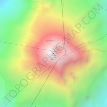
Name: Topografische Karte Pico de Orizaba, Höhe, Relief.
Ort: Pico de Orizaba, Chalchicomula de Sesma, Puebla, Mexico (19.03024 -97.26986 19.03034 -97.26976)
Durchschnittliche Höhe: 4.967 m
Minimale Höhe: 4.327 m
Maximale Höhe: 5.589 m
Pico de Orizaba, also known as Citlaltépetl (from Nahuatl citlal(in) = star, and tepētl = mountain), is an active stratovolcano, the highest mountain in Mexico and third highest in North America, after Denali of United States and Mount Logan of Canada. Pico de Orizaba is also the highest volcano in North America. It rises 5,636 metres (18,491 ft) above sea level in the eastern end of the Trans-Mexican Volcanic Belt, on the border between the states of Veracruz and Puebla. The volcano is currently dormant but not extinct, with the last eruption taking place during the 19th century. It is the second most prominent volcanic peak in the world after Mount Kilimanjaro. Pico de Orizaba is ranked 16th by topographic isolation.
Andere topografische Karten
Klicken Sie auf eine Karte, um ihre Topografie, ihre Höhe und ihr Relief anzuzeigen.
Sierra Negra
Mexico > Puebla > Chalchicomula de Sesma
Sierra Negra, Chalchicomula de Sesma, Puebla, Mexico
Durchschnittliche Höhe: 4.099 m