
Topografische Karte Loch Lomond and The Trossachs National Park
Interaktive Karte
Klicken Sie auf die Karte, um die Höhe anzuzeigen.
Loch Lomond and The Trossachs National Park
The park straddles the Highland Boundary Fault, which divides it into two distinct regions - lowland and highland - that differ in underlying geology, soil types and topography. The change in rock type can most clearly be seen at Loch Lomond itself, as the fault runs across the islands of Inchmurrin, Creinch, Torrinch and Inchcailloch and over the ridge of Conic Hill. To the south lie green fields and cultivated land; to the north, mountains.
Über diese Karte
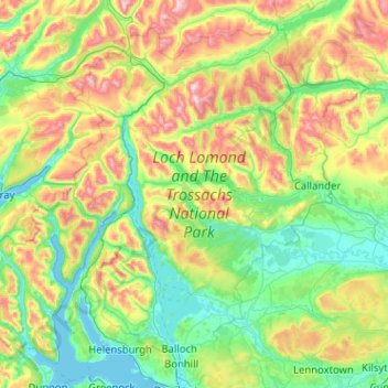
Name: Topografische Karte Loch Lomond and The Trossachs National Park, Höhe, Relief.
Durchschnittliche Höhe: 291 m
Minimale Höhe: -1 m
Maximale Höhe: 1.137 m
Andere topografische Karten
Klicken Sie auf eine Karte, um ihre Topografie, ihre Höhe und ihr Relief anzuzeigen.