
Topografische Karte Gangtok district
Interaktive Karte
Klicken Sie auf die Karte, um die Höhe anzuzeigen.
Über diese Karte
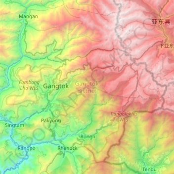
Name: Topografische Karte Gangtok district, Höhe, Relief.
Ort: Gangtok district, Sikkim, India (27.23001 88.43785 27.42146 88.92137)
Durchschnittliche Höhe: 2.334 m
Minimale Höhe: 233 m
Maximale Höhe: 5.196 m
Andere topografische Karten
Klicken Sie auf eine Karte, um ihre Topografie, ihre Höhe und ihr Relief anzuzeigen.
Lachung
India > Sikkim > Chungthang
Lachung, Chungthang, North Sikkim District, Sikkim, India
Durchschnittliche Höhe: 3.617 m
Katao
India > Sikkim > Chungthang
Katao, Chungthang, North Sikkim District, Sikkim, India
Durchschnittliche Höhe: 4.505 m
East District
India > Sikkim > East District
East District, East Sikkim District, Sikkim, India
Durchschnittliche Höhe: 2.740 m