
Topografische Karte Bronville
Interaktive Karte
Klicken Sie auf die Karte, um die Höhe anzuzeigen.
Über diese Karte
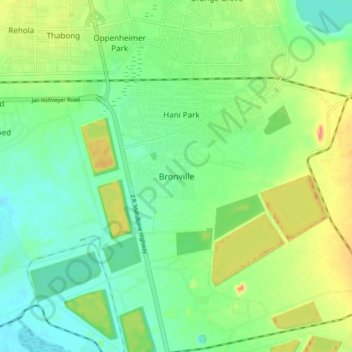
Name: Topografische Karte Bronville, Höhe, Relief.
Durchschnittliche Höhe: 1.365 m
Minimale Höhe: 1.340 m
Maximale Höhe: 1.410 m
Andere topografische Karten
Klicken Sie auf eine Karte, um ihre Topografie, ihre Höhe und ihr Relief anzuzeigen.
Rietspruit Dam
South Africa > Free State > Lejweleputswa District Municipality > Matjhabeng Local Municipality
Rietspruit Dam, Matjhabeng Ward 3, Matjhabeng Local Municipality, Lejweleputswa District Municipality, Free State, South Africa
Durchschnittliche Höhe: 1.364 m
Harmony
South Africa > Free State > Lejweleputswa District Municipality > Matjhabeng Local Municipality
Harmony, Matjhabeng Local Municipality, Lejweleputswa District Municipality, Free State, South Africa
Durchschnittliche Höhe: 1.333 m
Riebeeckstad
South Africa > Free State > Lejweleputswa District Municipality > Matjhabeng Local Municipality
Riebeeckstad, Matjhabeng Local Municipality, Lejweleputswa District Municipality, Free State, 9649, South Africa
Durchschnittliche Höhe: 1.384 m
Odendaalsrus
South Africa > Free State > Lejweleputswa District Municipality > Matjhabeng Local Municipality > Odendaalsrus
Odendaalsrus, Matjhabeng Local Municipality, Lejweleputswa District Municipality, Free State, 9480, South Africa
Durchschnittliche Höhe: 1.336 m
Hennenman
South Africa > Free State > Lejweleputswa District Municipality > Matjhabeng Local Municipality
Hennenman, Matjhabeng Local Municipality, Lejweleputswa District Municipality, Free State, 9445, South Africa
Durchschnittliche Höhe: 1.397 m