
Topografische Karte Lousã
Interaktive Karte
Klicken Sie auf die Karte, um die Höhe anzuzeigen.
Über diese Karte
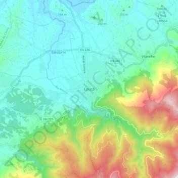
Name: Topografische Karte Lousã, Höhe, Relief.
Ort: Lousã, Lousã e Vilarinho, Lousã, Coimbra, 3200-200, Portugal (40.07115 -8.28616 40.15115 -8.20616)
Durchschnittliche Höhe: 335 m
Minimale Höhe: 75 m
Maximale Höhe: 1.048 m
Lousã sits at around 200 m (660 ft) high, and it currently has an active station at its aerodrome, but because this station is relatively new, data from the older, now inactive station in the mountains nearby, at a higher altitude, is also represented in the climate chart below: