
Topografische Karte Mégange
Interaktive Karte
Klicken Sie auf die Karte, um die Höhe anzuzeigen.
Über diese Karte
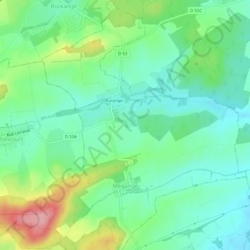
Name: Topografische Karte Mégange, Höhe, Relief.
Durchschnittliche Höhe: 241 m
Minimale Höhe: 200 m
Maximale Höhe: 335 m
Andere topografische Karten
Klicken Sie auf eine Karte, um ihre Topografie, ihre Höhe und ihr Relief anzuzeigen.
Grindorff-Bizing
Grindorff-Bizing, Thionville, Moselle, Grand Est, Metropolitan France, 57480, France
Durchschnittliche Höhe: 265 m
Moor
France > Grand Est > Moselle > Loudrefing
Moor, Loudrefing, Sarrebourg-Château-Salins, Moselle, Grand Est, Metropolitan France, 57670, France
Durchschnittliche Höhe: 241 m
Bouzonville
Bouzonville, Forbach-Boulay-Moselle, Moselle, Grand Est, Metropolitan France, 57320, France
Durchschnittliche Höhe: 234 m
Walschbronn
Walschbronn, Sarreguemines, Moselle, Grand Est, Metropolitan France, 57720, France
Durchschnittliche Höhe: 328 m
57230
France > Grand Est > Moselle > Éguelshardt
57230, Éguelshardt, Sarreguemines, Moselle, Grand Est, Metropolitan France, France
Durchschnittliche Höhe: 307 m
Vic-sur-Seille
Vic-sur-Seille, Sarrebourg-Château-Salins, Moselle, Grand Est, Metropolitan France, 57630, France
Durchschnittliche Höhe: 240 m
Mont Saint-Quentin
France > Grand Est > Moselle > Scy-Chazelles
Mont Saint-Quentin, Scy-Chazelles, Metz, Moselle, Grand Est, Metropolitan France, 57160, France
Durchschnittliche Höhe: 237 m
Craincourt
Craincourt, Sarrebourg-Château-Salins, Moselle, Grand Est, Metropolitan France, 57590, France
Durchschnittliche Höhe: 219 m
Longeville-lès-Saint-Avold
Longeville-lès-Saint-Avold, Forbach-Boulay-Moselle, Moselle, Grand Est, Metropolitan France, 57740, France
Durchschnittliche Höhe: 304 m
Henriville
Henriville, Forbach-Boulay-Moselle, Moselle, Grand Est, Metropolitan France, 57450, France
Durchschnittliche Höhe: 281 m
Creutzwald
Creutzwald, Forbach-Boulay-Moselle, Moselle, Grand Est, Metropolitan France, 57150, France
Durchschnittliche Höhe: 237 m
Gravelotte
Gravelotte, Metz, Moselle, Grand Est, Metropolitan France, 57130, France
Durchschnittliche Höhe: 301 m
Serémange-Erzange
Serémange-Erzange, Thionville, Moselle, Grand Est, Metropolitan France, 57290, France
Durchschnittliche Höhe: 209 m
Cité Émile Huchet
France > Grand Est > Moselle > Saint-Avold
Cité Émile Huchet, Saint-Avold, Forbach-Boulay-Moselle, Moselle, Grand Est, Metropolitan France, 57500, France
Durchschnittliche Höhe: 253 m
Montigny-lès-Metz
Montigny-lès-Metz, Metz, Moselle, Grand Est, Metropolitan France, 57950, France
Durchschnittliche Höhe: 179 m
Berg-sur-Moselle
Berg-sur-Moselle, Thionville, Moselle, Grand Est, Metropolitan France, 57570, France
Durchschnittliche Höhe: 168 m
Mattel
France > Grand Est > Moselle > Sarrebourg
Mattel, Hoff, Sarrebourg, Sarrebourg-Château-Salins, Moselle, Grand Est, Metropolitan France, 57400, France
Durchschnittliche Höhe: 269 m
Hannocourt
France > Grand Est > Moselle > Hannocourt
Hannocourt, Sarrebourg-Château-Salins, Moselle, Grand Est, Metropolitan France, 57590, France
Durchschnittliche Höhe: 257 m
Saint-Quirin
France > Grand Est > Moselle > Saint-Quirin
Saint-Quirin, Sarrebourg-Château-Salins, Moselle, Grand Est, Metropolitan France, 57560, France
Durchschnittliche Höhe: 432 m
Audun-le-Tiche
France > Grand Est > Moselle > Audun-le-Tiche
Audun-le-Tiche, Thionville, Moselle, Grand Est, Metropolitan France, 57390, France
Durchschnittliche Höhe: 383 m