
Topografische Karte Basco
Interaktive Karte
Klicken Sie auf die Karte, um die Höhe anzuzeigen.
Über diese Karte
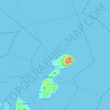
Name: Topografische Karte Basco, Höhe, Relief.
Ort: Basco, Batanes, Cagayan Valley, 3900, Philippines (20.35347 121.81641 20.61556 122.18024)
Durchschnittliche Höhe: 9 m
Minimale Höhe: 0 m
Maximale Höhe: 999 m
Andere topografische Karten
Klicken Sie auf eine Karte, um ihre Topografie, ihre Höhe und ihr Relief anzuzeigen.
Itbayat Island
Philippines > Batanes > Itbayat
Itbayat Island, Itbayat, Batanes, Cagayan Valley, 3905, Philippines
Durchschnittliche Höhe: 31 m
Itbayat
Itbayat, Batanes, Cagayan Valley, 3905, Philippines
Durchschnittliche Höhe: 1 m
Batan Island
Philippines > Batanes > Mahatao
Batan Island, Mahatao, Batanes, Cagayan Valley, 3901, Philippines
Durchschnittliche Höhe: 45 m
Padang
Padang, Sabtang, Batanes, Cagayan Valley, 3904, Philippines
Durchschnittliche Höhe: 113 m