
Topografische Karte Richland
Interaktive Karte
Klicken Sie auf die Karte, um die Höhe anzuzeigen.
Richland
According to the United States Census Bureau, the city has a total area of 39.11 square miles (101.29 km2), of which, 35.72 square miles (92.51 km2) is land and 3.39 square miles (8.78 km2) is water. Elevation at the airport is 120 m (390 ft).
Über diese Karte
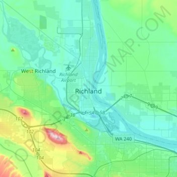
Name: Topografische Karte Richland, Höhe, Relief.
Ort: Richland, Benton County, Washington, United States (46.19440 -119.40044 46.37063 -119.21148)
Durchschnittliche Höhe: 160 m
Minimale Höhe: 93 m
Maximale Höhe: 483 m