
Topografische Karte Ellsworth
Interaktive Karte
Klicken Sie auf die Karte, um die Höhe anzuzeigen.
Über diese Karte
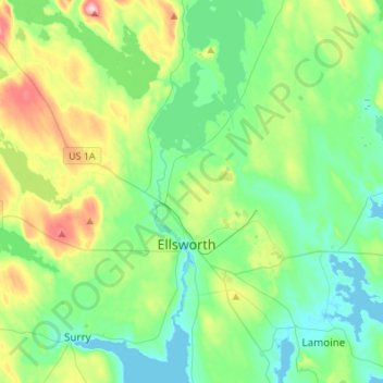
Name: Topografische Karte Ellsworth, Höhe, Relief.
Ort: Ellsworth, Hancock County, Maine, United States (44.47244 -68.63976 44.66615 -68.38411)
Durchschnittliche Höhe: 53 m
Minimale Höhe: -2 m
Maximale Höhe: 198 m
Andere topografische Karten
Klicken Sie auf eine Karte, um ihre Topografie, ihre Höhe und ihr Relief anzuzeigen.
Battle Island
United States > Maine > Hancock County > Penobscot
Battle Island, Penobscot, Hancock County, Maine, 04476, United States
Durchschnittliche Höhe: 53 m
Upper Chain Lake
United States > Maine > Hancock County
Upper Chain Lake, Hancock County, Maine, United States
Durchschnittliche Höhe: 110 m
Bar Harbor
United States > Maine > Hancock County
Bar Harbor, Hancock County, Maine, 04609, United States
Durchschnittliche Höhe: 33 m
Dedham
United States > Maine > Hancock County
Dedham, Hancock County, Maine, 04429, United States
Durchschnittliche Höhe: 112 m
Ship Island
United States > Maine > Hancock County > Tremont
Ship Island, Tremont, Hancock County, Maine, United States
Durchschnittliche Höhe: 0 m
Deer Isle
United States > Maine > Hancock County > Deer Isle
Deer Isle, Hancock County, Maine, United States
Durchschnittliche Höhe: 10 m