
Spenden
Rüste dich für dein nächstes Abenteuer:
Als Amazon-Partner verdient diese Website an qualifizierten Käufen, ohne zusätzliche Kosten für Sie.
Topografische Karte Port Hope
Klicken Sie auf die Karte, um die Höhe anzuzeigen.
Spenden
Rüste dich für dein nächstes Abenteuer:
Als Amazon-Partner verdient diese Website an qualifizierten Käufen, ohne zusätzliche Kosten für Sie.
Über diese Karte
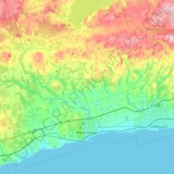
Name: Topografische Karte Port Hope, Höhe, Relief.
Durchschnittliche Höhe: 161 m
Minimale Höhe: 73 m
Maximale Höhe: 354 m
Spenden
Rüste dich für dein nächstes Abenteuer:
Als Amazon-Partner verdient diese Website an qualifizierten Käufen, ohne zusätzliche Kosten für Sie.
Andere topografische Karten
Klicken Sie auf eine Karte, um ihre Topografie, ihre Höhe und ihr Relief anzuzeigen.
Vernonville
Canada > Ontario > Northumberland County > Alnwick/Haldimand
Durchschnittliche Höhe: 196 m
Pethericks Corners
Canada > Ontario > Northumberland County > Trent Hills
Durchschnittliche Höhe: 181 m
Spenden
Rüste dich für dein nächstes Abenteuer:
Als Amazon-Partner verdient diese Website an qualifizierten Käufen, ohne zusätzliche Kosten für Sie.
Spenden
Rüste dich für dein nächstes Abenteuer:
Als Amazon-Partner verdient diese Website an qualifizierten Käufen, ohne zusätzliche Kosten für Sie.
Garden Hill Conservation Area
Canada > Ontario > Northumberland County > Port Hope > Garden Hill
Durchschnittliche Höhe: 192 m
Trent River
Canada > Ontario > Northumberland County > Trent Hills > Trent River
Durchschnittliche Höhe: 197 m
Camborne
Canada > Ontario > Northumberland County > Hamilton Township > Camborne
Durchschnittliche Höhe: 196 m
Spenden
Rüste dich für dein nächstes Abenteuer:
Als Amazon-Partner verdient diese Website an qualifizierten Käufen, ohne zusätzliche Kosten für Sie.
Spenden
Rüste dich für dein nächstes Abenteuer:
Als Amazon-Partner verdient diese Website an qualifizierten Käufen, ohne zusätzliche Kosten für Sie.
Ferris Provincial Park
Canada > Ontario > Northumberland County > Trent Hills > Campbellford
Durchschnittliche Höhe: 151 m
Spenden
Rüste dich für dein nächstes Abenteuer:
Als Amazon-Partner verdient diese Website an qualifizierten Käufen, ohne zusätzliche Kosten für Sie.
Spenden
Rüste dich für dein nächstes Abenteuer:
Als Amazon-Partner verdient diese Website an qualifizierten Käufen, ohne zusätzliche Kosten für Sie.
Cold Springs
Canada > Ontario > Northumberland County > Hamilton Township
Durchschnittliche Höhe: 249 m