
Topografische Karte Iraq Al-Amir
Interaktive Karte
Klicken Sie auf die Karte, um die Höhe anzuzeigen.
Über diese Karte
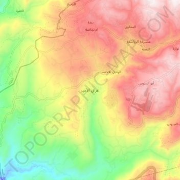
Name: Topografische Karte Iraq Al-Amir, Höhe, Relief.
Durchschnittliche Höhe: 487 m
Minimale Höhe: -49 m
Maximale Höhe: 932 m
'Iraq al-Amir or Araq el-Amir (Arabic:عراق الأمير - literally, "Caves of the Prince"), is the name shared by a town and nearby caves, within the municipality of Amman in the Jordan Valley. Located about 15 km southwest of the town of Wadi as-Seer, it has a population of about 6000 people, mostly members of the Abbadi tribe. It is located on hills with high and medium altitude, in an area with many springs and famous for its olive trees and other forest trees.
Andere topografische Karten
Klicken Sie auf eine Karte, um ihre Topografie, ihre Höhe und ihr Relief anzuzeigen.
الوادي الاخضر
Jordan > Amman > Wadi Essier Sub-District
الوادي الاخضر, Wadi Essier Sub-District, Wadi Essier District, Amman, Jordan
Durchschnittliche Höhe: 621 m
Um Nuwwarah
Jordan > Amman > Wadi Essier Sub-District
Um Nuwwarah, Wadi Essier Sub-District, Wadi Essier District, Amman, 11814, Jordan
Durchschnittliche Höhe: 779 m
Sare
Jordan > Amman > Wadi Essier Sub-District
Sare, Bayader, Wadi Al-Seer, Wadi Essier Sub-District, Wadi Essier District, Amman, 11814, Jordan
Durchschnittliche Höhe: 900 m
مشيرفة الرواشدة
Jordan > Amman > Wadi Essier Sub-District > مشيرفة الرواشدة
مشيرفة الرواشدة, Wadi Essier Sub-District, Wadi Essier District, Amman, Jordan
Durchschnittliche Höhe: 726 m