
Spenden
Rüste dich für dein nächstes Abenteuer:
Als Amazon-Partner verdient diese Website an qualifizierten Käufen, ohne zusätzliche Kosten für Sie.
Topografische Karte Batchewana
Klicken Sie auf die Karte, um die Höhe anzuzeigen.
Spenden
Rüste dich für dein nächstes Abenteuer:
Als Amazon-Partner verdient diese Website an qualifizierten Käufen, ohne zusätzliche Kosten für Sie.
Über diese Karte
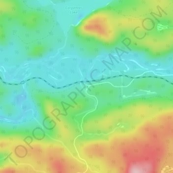
Name: Topografische Karte Batchewana, Höhe, Relief.
Durchschnittliche Höhe: 370 m
Minimale Höhe: 291 m
Maximale Höhe: 514 m
Spenden
Rüste dich für dein nächstes Abenteuer:
Als Amazon-Partner verdient diese Website an qualifizierten Käufen, ohne zusätzliche Kosten für Sie.
Andere topografische Karten
Klicken Sie auf eine Karte, um ihre Topografie, ihre Höhe und ihr Relief anzuzeigen.
Kabinakagami Lake
Canada > Ontario > Algoma District > Unorganized North Algoma
Durchschnittliche Höhe: 332 m
Lucille Lake;Wood Creek
Canada > Ontario > Algoma District > Unorganized North Algoma
Durchschnittliche Höhe: 441 m
Alpha Lake
Canada > Ontario > Algoma District > Unorganized North Algoma
Durchschnittliche Höhe: 314 m
Daisy Lake
Canada > Ontario > Algoma District > Unorganized North Algoma
Durchschnittliche Höhe: 457 m
Spenden
Rüste dich für dein nächstes Abenteuer:
Als Amazon-Partner verdient diese Website an qualifizierten Käufen, ohne zusätzliche Kosten für Sie.
Raven Lake
Canada > Ontario > Algoma District > Unorganized North Algoma
Durchschnittliche Höhe: 371 m
Burnt Lake
Canada > Ontario > Algoma District > Unorganized North Algoma
Durchschnittliche Höhe: 444 m
Moccasin Lake
Canada > Ontario > Algoma District > Unorganized North Algoma
Durchschnittliche Höhe: 477 m
Clayton Lake
Canada > Ontario > Algoma District > Unorganized North Algoma
Durchschnittliche Höhe: 381 m
Spenden
Rüste dich für dein nächstes Abenteuer:
Als Amazon-Partner verdient diese Website an qualifizierten Käufen, ohne zusätzliche Kosten für Sie.
Caddy Lake
Canada > Ontario > Algoma District > Unorganized North Algoma
Durchschnittliche Höhe: 424 m
Northland Lake
Canada > Ontario > Algoma District > Unorganized North Algoma
Durchschnittliche Höhe: 387 m
Manitowik Lake
Canada > Ontario > Algoma District > Unorganized North Algoma
Durchschnittliche Höhe: 394 m
Spenden
Rüste dich für dein nächstes Abenteuer:
Als Amazon-Partner verdient diese Website an qualifizierten Käufen, ohne zusätzliche Kosten für Sie.
Mosambik Lake
Canada > Ontario > Algoma District > Unorganized North Algoma
Durchschnittliche Höhe: 363 m
Goulais River
Canada > Ontario > Algoma District > Unorganized North Algoma
Durchschnittliche Höhe: 362 m
Fire River
Canada > Ontario > Algoma District > Unorganized North Algoma
Durchschnittliche Höhe: 399 m
Kimiwan Creek;Kimiwan Lakes
Canada > Ontario > Algoma District > Unorganized North Algoma
Durchschnittliche Höhe: 442 m
Spenden
Rüste dich für dein nächstes Abenteuer:
Als Amazon-Partner verdient diese Website an qualifizierten Käufen, ohne zusätzliche Kosten für Sie.
Montreal River
Canada > Ontario > Algoma District > Unorganized North Algoma
Durchschnittliche Höhe: 360 m
Tilley Lakes
Canada > Ontario > Algoma District > Unorganized North Algoma
Durchschnittliche Höhe: 301 m
Limerick Lake
Canada > Ontario > Algoma District > Unorganized North Algoma
Durchschnittliche Höhe: 505 m
Mashagama Lake
Canada > Ontario > Algoma District > Unorganized North Algoma
Durchschnittliche Höhe: 458 m
Spenden
Rüste dich für dein nächstes Abenteuer:
Als Amazon-Partner verdient diese Website an qualifizierten Käufen, ohne zusätzliche Kosten für Sie.
Montreal Island
Canada > Ontario > Algoma District > Unorganized North Algoma
Durchschnittliche Höhe: 190 m
Lanier Lake
Canada > Ontario > Algoma District > Unorganized North Algoma
Durchschnittliche Höhe: 403 m
Seymour Lake
Canada > Ontario > Algoma District > Unorganized North Algoma
Durchschnittliche Höhe: 436 m
Kabinakagamisis Lake
Canada > Ontario > Algoma District > Unorganized North Algoma
Durchschnittliche Höhe: 324 m
Spenden
Rüste dich für dein nächstes Abenteuer:
Als Amazon-Partner verdient diese Website an qualifizierten Käufen, ohne zusätzliche Kosten für Sie.
Chapleau River
Canada > Ontario > Algoma District > Unorganized North Algoma
Durchschnittliche Höhe: 328 m
Wakomata Lake
Canada > Ontario > Algoma District > Unorganized North Algoma
Durchschnittliche Höhe: 380 m
Esnagi Lake
Canada > Ontario > Algoma District > Unorganized North Algoma
Durchschnittliche Höhe: 391 m
Flack Lake
Canada > Ontario > Algoma District > Unorganized North Algoma
Durchschnittliche Höhe: 384 m
Spenden
Rüste dich für dein nächstes Abenteuer:
Als Amazon-Partner verdient diese Website an qualifizierten Käufen, ohne zusätzliche Kosten für Sie.