
Topografische Karte Elizabethton
Interaktive Karte
Klicken Sie auf die Karte, um die Höhe anzuzeigen.
Über diese Karte
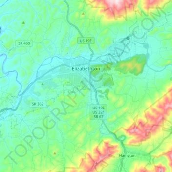
Name: Topografische Karte Elizabethton, Höhe, Relief.
Durchschnittliche Höhe: 567 m
Minimale Höhe: 434 m
Maximale Höhe: 1.015 m
The elevation at Elizabethton Municipal Airport is 1,593 feet (486 m) ASL (the highest point of elevation in Carter County is at Roan Mountain with an elevation of 6,285 feet (1,916 m) ASL), and the airport is located on the eastern side of the city along State Highway 91 Stoney Creek Exit. Elizabethton is also connected to larger commercial, shuttle, and cargo flights out of Tri-Cities Regional Airport northwest of Johnson City.
Andere topografische Karten
Klicken Sie auf eine Karte, um ihre Topografie, ihre Höhe und ihr Relief anzuzeigen.
Roan Mountain
United States > Tennessee > Carter County
Roan Mountain, Carter County, East Tennessee, Tennessee, United States
Durchschnittliche Höhe: 1.418 m
Watauga
United States > Tennessee > Carter County
Watauga, Carter County, East Tennessee, Tennessee, United States
Durchschnittliche Höhe: 465 m
Roan Mountain
United States > Tennessee > Carter County
Roan Mountain, Carter County, East Tennessee, Tennessee, 37687, United States
Durchschnittliche Höhe: 926 m
Elk Mills
United States > Tennessee > Carter County
Elk Mills, Carter County, East Tennessee, Tennessee, United States
Durchschnittliche Höhe: 749 m
Buckeye Gap
United States > Tennessee > Carter County
Buckeye Gap, Carter County, Tennessee, United States
Durchschnittliche Höhe: 1.360 m
Watauga River
United States > Tennessee > Carter County > Elizabethton
Watauga River, Elizabethton, Carter County, East Tennessee, Tennessee, 37694, United States
Durchschnittliche Höhe: 482 m
Whitehead Hill
United States > Tennessee > Carter County
Whitehead Hill, Carter County, Tennessee, 37658, United States
Durchschnittliche Höhe: 803 m
Pond Mountain
United States > Tennessee > Carter County
Pond Mountain, Carter County, Tennessee, United States
Durchschnittliche Höhe: 976 m
Elizabethton
United States > Tennessee > Carter County > Elizabethton > Elizabethton
Elizabethton, Carter County, Tennessee, 37643, United States
Durchschnittliche Höhe: 527 m
Hampton
United States > Tennessee > Carter County
Hampton, Carter County, East Tennessee, Tennessee, 37658, United States
Durchschnittliche Höhe: 674 m