
Topografische Karte Peat Inn
Klicken Sie auf die Karte, um die Höhe anzuzeigen.
Über diese Karte
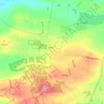
Name: Topografische Karte Peat Inn, Höhe, Relief.
Ort: Peat Inn, Fife, Scotland, KY15 5LH, United Kingdom (56.25740 -2.90389 56.29740 -2.86389)
Durchschnittliche Höhe: 175 m
Minimale Höhe: 117 m
Maximale Höhe: 238 m
Andere topografische Karten
Klicken Sie auf eine Karte, um ihre Topografie, ihre Höhe und ihr Relief anzuzeigen.
Inverkeithing
United Kingdom > Scotland > Fife
Topographically, Inverkeithing is situated on a raised terrace sloping down towards Inverkeithing Bay, which cuts in to the south of the town, separating it from the North Queensferry peninsula. Its medieval centre lay along High Street and Church Street, but the town has since expanded to encompass areas to…
Durchschnittliche Höhe: 28 m
Kellie Castle
United Kingdom > Scotland > Fife > Arncroach > Newton of Balcormo
Durchschnittliche Höhe: 69 m
Tentsmuir National Nature Reserve
United Kingdom > Scotland > Fife > Tayport
Durchschnittliche Höhe: 4 m
Run Free Secure Dog Fields
United Kingdom > Scotland > Fife > Inverkeithing
Durchschnittliche Höhe: 38 m