
Topografische Karte Orofino
Interaktive Karte
Klicken Sie auf die Karte, um die Höhe anzuzeigen.
Über diese Karte
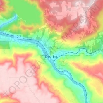
Name: Topografische Karte Orofino, Höhe, Relief.
Ort: Orofino, Clearwater County, Idaho, 83544, United States (46.47097 -116.32122 46.49939 -116.19855)
Durchschnittliche Höhe: 633 m
Minimale Höhe: 293 m
Maximale Höhe: 964 m
The city has a climate typical of low-elevation areas in Idaho and eastern Washington. Orofino has a dry-summer continental climate (Köppen Dsb). Due to the warm summers, it nearly qualifies as a continental Mediterranean climate (Dsa). Idaho’s all-time highest temperature of 118 °F or 47.8 °C was recorded at Orofino on July 28, 1934.
Andere topografische Karten
Klicken Sie auf eine Karte, um ihre Topografie, ihre Höhe und ihr Relief anzuzeigen.
Clearwater County
United States > Idaho > Clearwater County
Clearwater County, Idaho, United States
Durchschnittliche Höhe: 1.250 m
Platinum Lake
United States > Idaho > Clearwater County
Platinum Lake, Clearwater County, Idaho, United States
Durchschnittliche Höhe: 1.723 m